
Between 1908 and 1911, in the midst of a booming rubber industry, the British government freed up 2,000 acres of forested lands at the north of Sungei Seletar for the cultivation of rubber plantations.
Several local firms seized the opportunity and invested in this undeveloped area, including big players such as Lim Nee Soon’s (1879-1936) Thong Aik Rubber Factory, Lee Kong Chian’s (1893-1967) Lee Rubber Factory, and the Sembawang Rubber Plantations Limited, co-founded by prominent Chinese pioneers Lim Boon Heng (1869-1957) and Tan Chay Yan (1871-1916). These companies hired a large number of rubber plantation and factory workers, most of them new immigrants from China.
Nee Soon Villages
Many of these workers settled around the plantations; this gave rise to the establishment of many villages at the Nee Soon area, especially along the main Seletar Road (renamed Sembawang Road in February 1939). The development of the Seletar Air Base in the 1920s also saw villagers at Jalan Kayu resettled to the Nee Soon villages.
In the 1930s, another wave of Chinese immigration led to population booms at Nee Soon. To accommodate the growing villages and help them to become self-sufficient, the British government in 1938 released another 1,000 acres of lands around Bah Soon Bah Road for vegetable and fruit farming.
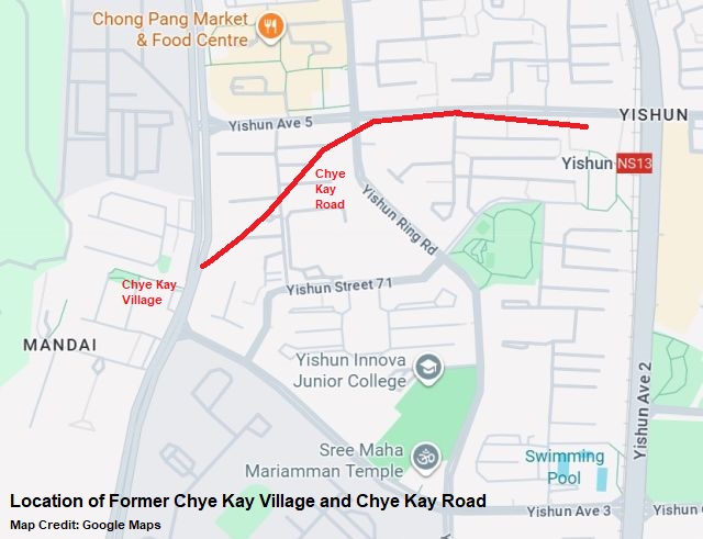
After the war, in a 1947 population census conducted by the government, there were about 23,000 residents living at the Nee Soon area. In 1954, to improve the efficiency of postal services, the village at Sembawang Road 11½ milestone was named Chye Kay Village (财启村), honouring Tan Chye Kay (陈财家), a well-respected Chinese pioneer and community leader who had previously owned many rubber and pineapple plantations at the Sembawang Road vicinity. Chye Kay Road was also named after him.
Public Amenities
The entrance of Chye Kay Village was located at the junction of Sembawang Road and Chye Kay Road. Before it was paved as an asphalt road in 1968, Chye Kay Road was a dirt track that branched off to other tracks in Lorong Achara, Lorong Peluang and Lorong Batu Giling.
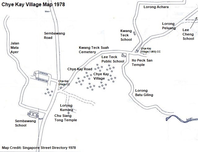
Chye Kay Village was predominantly made up of Chinese residents and several Indian families. Like other early villages in Singapore, it had self-sufficient public amenities to serve the residents’ needs, such as schools, community centres, kopitiams, provision shops, temples and even a burial ground.
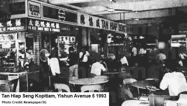
Before the seventies, the entire Nee Soon area had only five kopitiams, two of which were at Chye Kay Village. One of Chye Kay’s kopitiams was the popular Tan Hiap Seng. Started in 1935, it had witnessed the rise and demise of Chye Kay Village. In 1977, the kopitiam shifted to the newly-built Yishun Avenue 5 when Chye Kay Village was being demolished.
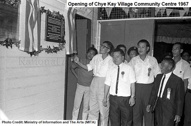
Chye Kay Village had two community centres built in the late sixties. At about 800m apart, they were the Chye Kay Village Community Centre and Chye Kay Village (½ Mile) Community Centre. Free films used to be aired at the community centres by the Ministry for Culture between the late sixties and early seventies.
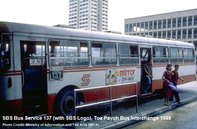
Public bus services were available but limited to the main Sembawang Road. The residents often had to walk lengthy distances into Chye Kay Village to reach their destinations. Under the United Bus Company (UBC), there were bus services 160, 161 and 164 plying along Sembawang Road in the early seventies. After its formation in 1973, the Singapore Bus Services (SBS) offered the bus service 169 that shuttled between Marsiling Road and Sembawang Road, with a loop point near Chye Kay Road.
Chinese Schools
Three Chinese schools were established at Chye Kay Village. They were the Kwang Teck School (广德学校), Lee Cheng School (励正学校) and Lee Teck Public School (公立励德学校). The first English school – Sembawang School along Sembawang Road – only appeared in the vicinity in the late 1940s.
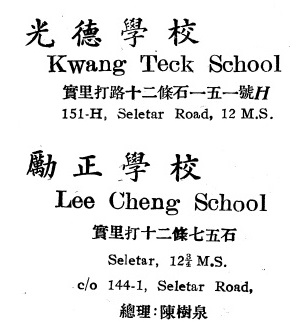 Kwang Teck School was founded in the 1930s by the Ngee Ann Kongsi, which sponsored both the land and construction costs of the school buildings. Located near the junction of Chye Kay Road and Lorong Achara, Kwang Teck School had an average student population of about 200.
Lee Cheng School was also established in the 1930s. It had about 300 students in the sixties and seventies. Before the construction of the community centres at Chye Kay Village, Lee Cheng School was often used as one of the venues for the Ministry for Culture’s screening of free movies for the residents.
A well-known alumni of Lee Cheng School was Peck Noi Hwoy, who learned and trained in table tennis when she was at the school. By the time she was 11, Peck Noi Hwoy had advanced to national ranks. She would go on to gain the top seed in Singapore’s table tennis’ national team, becoming the national singles champion in 1966 and 1968.
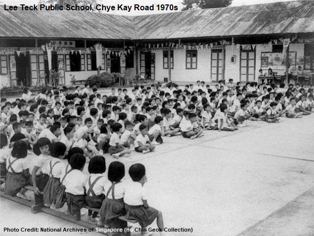
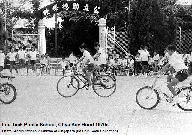
Chye Kay Village’s third school Lee Teck Public School was built in 1948, shortly after the war. Its construction was funded through the charitable efforts of the residents in the village.
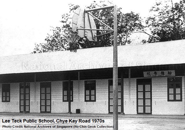
In 1971, the British’s Royal Engineers helped the school to build a basketball court in front of the school building, which was previously a swampy playground. The soldiers were also involved in the painting of the school building’s roof, repairing of the drains and paving of a walkway that led to the classrooms.
The notorious “kidnap king” Oh Kirn Kee (胡金枝) of the fifties was from Chye Kay Village and Lee Teck Public School. Armed with two firearms, he committed a dozen of kidnapping and robbery cases in just one year during the late fifties. In August 1960, the 29-year-old criminal was shot dead by the Criminal Investigation Department (CID) plain-clothes officers at Geylang.
All the three schools were shut down in the late seventies, walking into the history together with Chye Kay Village. Kwang Teck School closed in 1976, followed by Lee Teck Public School a year later. Lee Cheng School was shuttered in 1979.
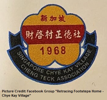 The names of Lee Teck and Lee Cheng Schools, however, live on in the form of an association that oversaw the welfare, benefits and communal support of the students and villagers.
The Singapore Chye Kay Village Cheng Teck Association’s (新加坡财启村正德社) name was derived from Lee Cheng School and Lee Teck School when it was formed in 1968. It is still a registered association with the Registry of Societies today.
Chinese Temples
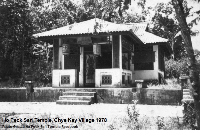
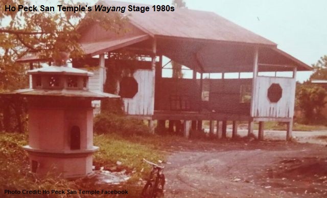
Chye Kay had several Chinese temples. Ho Peck San Temple (何碧山宫) was established at Chye Kay Village in the early 20th century, where its main deity Lord Qi was worshipped by the devotees. The Taoist temple began as a simple shrine before it was rebuilt as a proper temple in 1950, with a wayang stage that also functioned as a classroom for students.
In 1984, Ho Peck San Temple was merged with Nam Hong Siang Theon (南凤善堂) and Seng Pang Tua Pek Kong Keng (成邦大伯公宫) to become Yishun’s first combined temple, located at the Chong Pang City off Yishun Ring Road.
Another Chye Kay temple was Chu Siang Tong Temple (聚善宫). It was founded at Bah Soon Bah Village in 1950 as a small shrine known as “Five Tigers Temple”, named after its deities.
In 1960, the temple was shifted to a site near the entrance of Chye Kay Village at Sembawang Road 11½ milestone. It would be where the Khatib Camp is today. Chu Siang Tong Temple, in 1987, was relocated a third time, to the junction of Yishun Avenue 2 and Yishun Ring Road and was merged with Wah Sua Keng Temple.
At the northern side of Chye Kay Road lied the burial ground named Kwong Teck Suah Teochew Cemetery, owned by the Ngee Ann Kongsi.
Golden Era
In 1962, as part of Singapore’s Master Plan, the zoning of Chye Kay Village was changed from rural zone to rural centre and settlement zone. This allowed the village to be considered for residential, retail and other types of development.
As a result, the village boomed between the sixties and seventies, where its population increased and a number of small businesses in transport, packaging, orchid farming and fish farming established and flourished at Chye Kay.
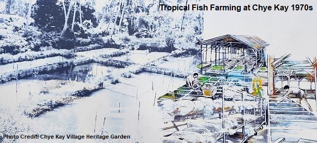
In particular, Chye Kay became well-known for its tropical fish breeding, especially guppies and tetras. It would make up about one-fifth of Singapore’s exports of tropical fish in the seventies.
Secret Societies
Fights and brawls between secret society members were rampant at the Sembawang area in the sixties and seventies. In 1966, the police arrested 22 men after armed clashes broke out between two secret societies Ang Soon Tong and Hong Kong San at Sembawang Road 13th milestone and Upper Thomson Road 6th milestone. The men were detained by the police under the Criminal Law (Temporary Provisions) Ordnance.
The secret societies of Ang Soon Tong, Hong Kong San, Sio Koon Tong, Gang 18 and Gang 21, continued to terrorise the Sembawang Road and Upper Thomson Road vicinities throughout the seventies.
Droughts and Fires
Fire hazards were another major concern. In 1967, a house at Chye Kay Road was gutted by fire. The Sim family, the owner of the house, managed to escape unhurt, but the house was destroyed. The 20 members of the Sim family was rendered homeless and had to be assisted by the Social Welfare Department.
In July 1972, the residents at Chye Kay Road were left with dried-up wells due to a prolonged drought. Other areas at the Sembawang area were also hit hard, including Lorong Limbang, Lorong Puyu, Lorong Mayang and Bah Soon Bah Road. The Public Utilities Board (PUB) activated their water wagons – each containing 1,900 litres of water for about 20 families – to supply water to the affected areas.
Gotong Royong
Like many other villages in Singapore, gotong royong works were often carried out for the paving and repairing of roads and tracks in the rural areas.
For example, in 1973, a gotong royong project was initiated for the Chye Kay area by Ong Soon Chuan, then-Parliamentary Secretary for Foreign Affairs and Member of Parliament for Nee Soon. More than 200 people participated, including the Chye Kay Village residents, national servicemen and Nee Soon’s youth group members.
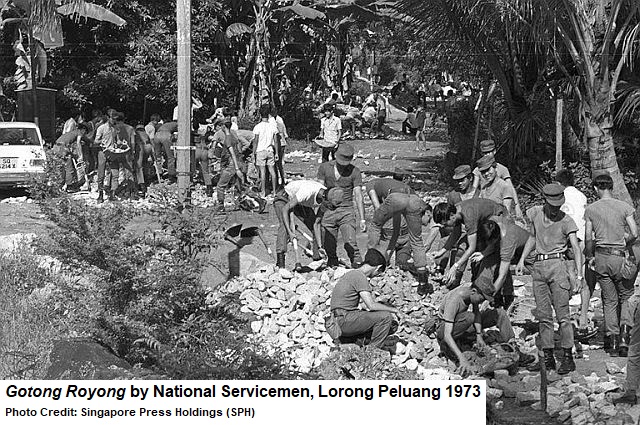
Using tools and machinery provided by the government, the project covered the paving of Lorong Peluang and Lorong Achara and the construction of roadside drains. Both tracks had become muddy over time due to a lack of roadside drains to channel away the excessive water during rainy days.
The paved roads greatly improved the accessibility for the residents of some 450 homes living along Chye Kay Road, Lorong Peluang and Lorong Achara.
Redevelopment Plans
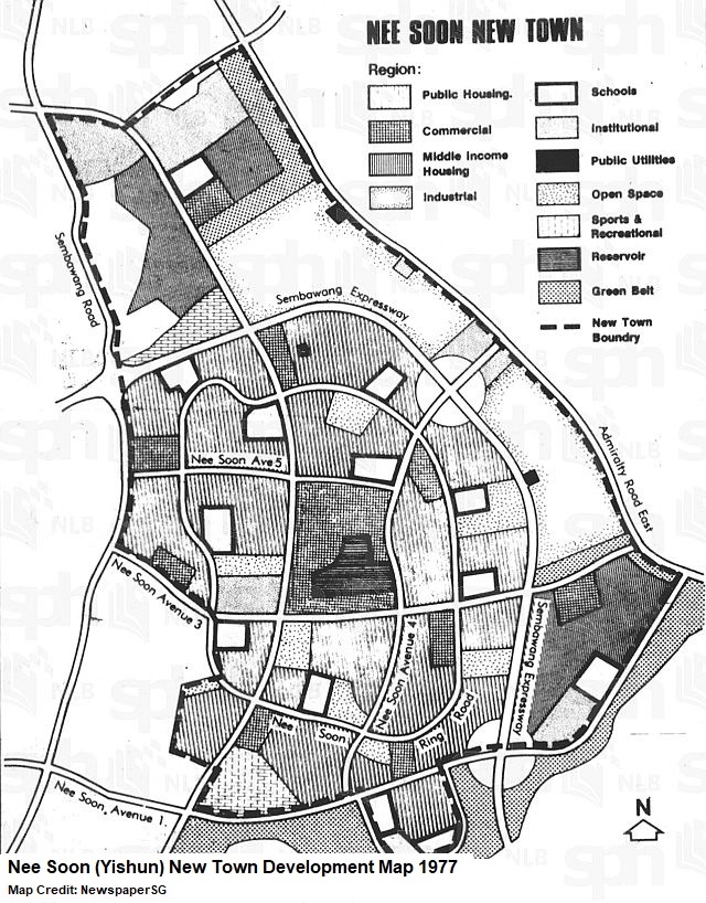
The Housing and Development Board’s (HDB) development of Nee Soon New Town (present-day Yishun New Town) began in 1977.
Large and small villages in the vicinity, including the ones at Chye Kay, Bah Soon Bah, Lorong Mayang, Jalan Ulu Seletar, Lorong Handalan, Lorong Pelita, Jalan Mata Ayer and Mandai Tekong, were all impacted.
For Chye Kay Village, its 5,000-strong population were resettled by the late seventies, many of them had to bid farewell to their longtime homes and see their beloved village torn down. Much of Chye Kay Road was expunged by 1982.
The HDB, between 1977 and 1981, also carried out the exhumation of the Kwang Teck Suah Cemetery. A Nee Soon Columbarium (present-day Yishun Columbarium) was built at the junction of Yishun Avenue 2 and Yishun Ring Road to store the remains of the 20,000 graves that were affected by the housing development projects.
Opened in 1982, the $1.4-million columbarium had more than 30 blocks housing 16,000 niches of remains largely from Kwang Teck Suah, Wah Suah Teng, Hock San Teng and Tong Gik cemeteries.
Nostalgic Reminiscences
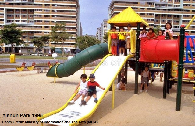
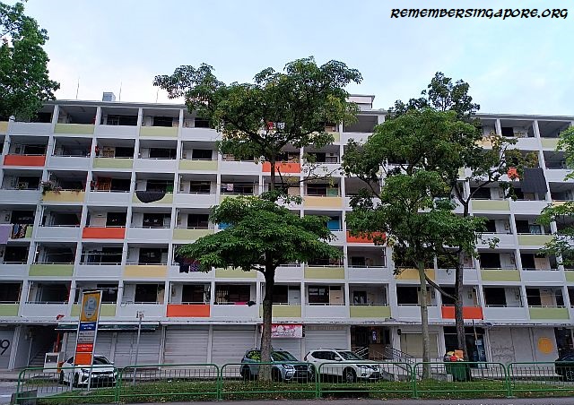
More high-rise HDB flats popped up at Yishun New Town throughout the eighties and nineties. Chye Kay Village was gone but not without traces. One could still find, in the mid-nineties, the reminiscences of Chye Kay Village when the Parks and Recreation Department built a park at a former rubber plantation of the village.
Named Yishun Park and opened in January 1995, it retained the fruit and rubber trees that were left behind during the resettlement and redevelopment of the vicinity.
Yishun’s first centenarian Neo Si Ki was from Chye Kay Village, who had witnessed almost the entire history and legacy of the village. She passed away in 1994 at a ripe old age of 103.
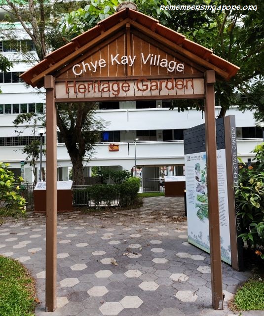
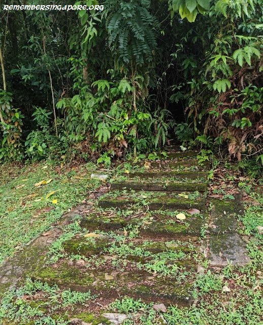
In 2019, a two-day exhibition on the history and memories of Chye Kay Village was held at Chong Pang. At Yishun Street 22, there is also a small Chye Kay Village Heritage Garden with displays showcasing the history of the former village.
Published: 31 March 2026


")

")

