
Along Yio Chu Kang Road once existed a Boh Sua Tian Road that extended into the rural parts of Seletar. The road was named after the nearby wireless station, which was formerly owned by the Royal Air Force (RAF) Seletar in the fifties and sixties. The name boh sua tian (无线电) means wireless in Hokkien and Teochew.
A Yio Chu Kang Village, also known as Kampong Boh Sua Tian, once existed at Yio Chu Kang Road 10th milestone (near the junction of Yio Chu Kang Road and Boh Sua Tian Road) as early as the 1930s. The large village, having a postal code of 28, was a bustling and self-sufficient one made up of hundreds of residents, attap and wooden houses, provision shops, vegetable and pig farms, durian orchards and fish ponds.
At the other end of Boh Sua Tian Road was another kampong called Kampong Pengkalan Petai, a Malay village that was located along Sungei Seletar (developed into Lower Seletar Reservoir in the late eighties).
In 1958, the Singapore Auxiliary Fire Services held its first fire-fighting course at Kampong Boh Sua Tian. The aim was to teach the residents of the safety measures such as fire prevention, as well as the methods of using fire extinguishers, water and sand buckets to fight fires. The course was also launched at other villages at Sembawang, Changi, Jurong, Bukit Panjang and Pasir Panjang.

A People’s Action Party (PAP) branch, named the Jalan Kayu-Boh Sua Tian Sub-branch, was opened in 1966 to serve the communities living between Boh Sua Tian Road and Jalan Kayu.
Boh Sua Tian Road was further developed in the seventies. It became longer and was branched off to other roads – mostly dirt tracks – named Lorong Gemilap, Lorong Anchak, Lorong Jirak, Lorong Andong, Lorong Selangin and Lorong Hablor.
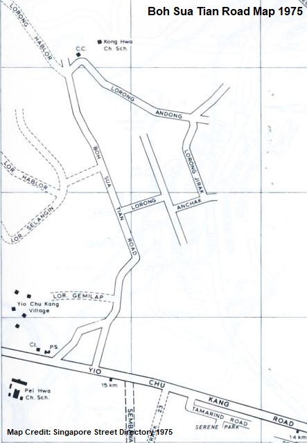 At its peak, Boh Sua Tian Road was home to numerous community centres, temples and schools, such as Sin Cheng Chinese School and Kong Hwa Chinese School. A Seletar Sewage Treatment Works was also installed at the junction of Boh Sua Tian Road and Lorong Andong in the seventies.
Like many other villages in Singapore, Kampong Boh Sua Tian also faced various issues such as poorly maintained roads, defective street lights, illegally dumped rubbish, clogged drains as well as gang fights and harassments. The history of the village eventually came to an end with the development of the Central Expressway (CTE). With the lands of their home acquired by the government, many of the residents, by the early eighties, had moved to nearby flats at Seletar Hills and Ang Mo Kio. Lorong Gemilap, the access road to the village, was expunged in 1988.

In 1984, the expansion project for the Lower Seletar Reservoir resulted in many trucks and heavy vehicles taking their daily routes via Boh Sua Tian Road. Due to the intensive usage of the road, Boh Sua Tian Road was filled with potholes, causing inconvenience to the remaining residents still living in the vicinity.
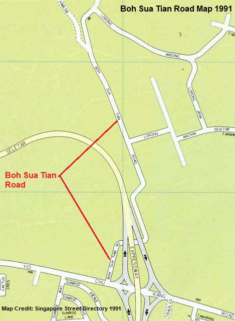 The first phase of the massive CTE project (between Yio Chu Kang Road and Bukit Timah Road) was completed in 1989, after which the development of the expressway was continued to be linked to the Seletar Expressway (SLE) and Tampines Expressway (TPE). In 1990, the direct link between SLE and CTE was officially opened for traffic.
Boh Sua Tian Road remained accessible in the early nineties, with an underpass constructed at the slip roads to the expressway. But by 1995, the road and its accompanying network of minor roads and tracks were closed to vehicular access and erased from the official maps. Their locations are now occupied by the interchange between the three expressways (CTE, SLE and TPE).
Today, a short remnant stretch of Boh Sua Tian Road (and the underpass) still exists, albeit forgotten over the years, under the slip roads (from Yio Chu Kang Road to CTE) and Yio Chu Kang Flyover.


Published: 30 June 2021
Discover more from Remember Singapore
Subscribe to get the latest posts sent to your email.


interesting….
Hello. I was the young lad who found and filmed the road to share light of it on youtube, and as a huge fan of your blog, it somehow feels like a honour to see your well researched write-up of the place. I learn a lot from your articles many thanks
~triadii
Cool! I searched “Boh Sua Tian Road” in YouTube and saw your video, well done!
I didn’t go to the other side because the vegetation was quite thick and I thought there was no stretches of Boh Sua Tian Road left. But after watching your video, I was wrong!
Maybe I will go take a look again someday 🙂 Thanks.
Interesting road history. Thank you for posting.
ANG HIAP LEE DEPARTMENTAL STORE
Block 629, Ang Mo Kio Avenue 4, 01-994
This stationery store has been serving residents in the neighbourhood since 1980. Run by the Ang family, Ang Hiap Lee used to operate as a furniture shop in a village near the former Boh Sua Tian Road along Yio Chu Kang Road. When redevelopment took off in the 1970s, the business was resettled to Ang Mo Kio, whereupon the family decided to sell stationery instead as there were no other such shops in the neighbourhood.
Ms Ang Bee Yan, who took over the shop from her father in 1984, recalls, “Ang Mo Kio was a new town then, and there were many school children. There were also many office workers from the industrial park. As such, business in the ‘80s was very brisk. Today, the younger generation has largely moved out to other estates and business has slowed down.”
Source: Ang Mo Kio A Heritage Trail
Hi, Jeffrey, thanks for sharing “Remember Singapore Series- Boh Ua Tian Rd” which is interesting and informative.
The contents of the write-up ( see text below) about Ang Hiap Lee Furniture Shop have caught my eyeballs. If I am not wrong, this furniture shop of 1960’ was owned by Ang Chai Yong, a teacher by training, together with his siblings. We were childhood friends from the same kampong. Sited near to the junction of Yio Chu Kang Rd and Boh Sua Tian Rd, this furniture shop was one of the bigger shops in a row of single storey shop houses directly facing the main Rd. The shop was doing well at that time. By late 1970, probably due to some govt road work, the shop was relocated to Ang Mo Kio Newtown and became a stationary shop . Direct opposite this furniture shop (across Yio Chu Kang Rd ) was the Soap Factory ( I mentioned it to you earlier) which was owned by my Auntie ( my mum side) of the Neo Family. In mid 1970, my cousin , after graduating from Nantah with a chemistry degree, took over the business from the parents. With his newly acquired technical knowledge he learned from Nantah, he converted the factory to a modern palm oil processing factory with its finish cooking oil products targeted at overseas export markets in Asia and Middle East. The business was doing extremely well for many years until its operation ceased in 2010 when the Neo family decided to migrate to Australia. To my surprise , there was no mention of the 2 soap and palm oil processing factories in the write up. As for Ang ChaiYong, I am still in contact with him. He has retired from the teaching and is running the stationary shops ( 2 shops) in Golden Mile Shopping Centre. Any objection that I share the write up with him and ask for his comments. ChaiTeck.
“ANG HIAP LEE DEPARTMENTAL STORE
Block 629, Ang Mo Kio Avenue 4, 01-994
This stationery store has been serving residents in the neighbourhood since 1980. Run by the Ang family, Ang Hiap Lee used to operate as a furniture shop in a village near the former Boh Sua Tian Road along Yio Chu Kang Road. When redevelopment took off in the 1970s, the business was resettled to Ang Mo Kio, whereupon the family decided to sell stationery instead as there were no other such shops in the neighbourhood.
Ms Ang Bee Yan, who took over the shop from her father in 1984, recalls, “Ang Mo Kio was a new town then, and there were many school children. There were also many office workers from the industrial park. As such, business in the ‘80s was very brisk. Today, the younger generation has largely moved out to other estates and business has slowed down.”
Source: Ang Mo Kio A Heritage Trail”
Valuable memories by residents formerly living at Boh Sua Tian Road
http://jalankayutrail.blogspot.com/2007/10/interview-with-local-residents-of-jalan.html
Not sure if there was a Boh Sua Tian Road Primary School
https://eresources.nlb.gov.sg/newspapers/Digitised/Article/newnation19790317-1.2.47