
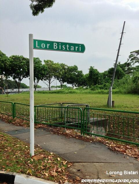
Lorong Bistari was one of the numerous roads that were expunged in the late eighties and early nineties due to the development of Choa Chu Kang New Town (Choa Chu Kang North, or Yew Tee today) and the expansion of the Kranji army camps.
The remaining 50m stretch of Lorong Bistari, off Choa Chu Kang Way, is still visible today, although it is no longer listed in most modern maps and street directories. The defunct road, along with its several old lamp posts, has been gradually forgotten. Other roads such as Lorong Chembol, Lorong Keduang and Lorong Puyu had long completely disappeared into history, while part of Lorong Kebasi (where the former Yew Tee Community Centre once stood) and Lorong Limbang (which gave rise to the naming of Limbang, one of the neigbourhoods at Choa Chu Kang North) were absorbed into the restricted premises of Kranji Camp.

Choa Chu Kang was a different picture in the sixties and seventies, where pig, poultry and vegetable farms were abundant. On the opposite side of Woodlands Road, there were granite mills and crushing plants for the Mandai Quarry, providing ample job opportunities for the villagers living in the vicinity. At Lorong Bistari, small businesses such as hardware shops and sawmills lined up along the road; Guan Seng, one of the sawmills, was destroyed in a fire in 1973. An estimated 150 tons of wooden planks and boards, reported to be worth $80,000, were consumed by the flames.

The Jurong Town Corporation (JTC) started developing a small light industrial estate at Choa Chu Kang North in the early eighties. It was named Yew Tee Industrial Estate, and was made up of rows of double-storey terrace workshops built in the area bounded by Woodlands Road, Stagmont Ring, the railway tracks and Peng Sua Canal. To boost the industry, parcels of vacant lands near Lorong Bistari, between 30,000 and 60,000 square feet, were made available for lease to small factories.

The Choa Chu Kang New Town was developed in the late eighties. By 1991, as many as 35,000 housing units were ready. However, Choa Chu Kang North, or Yew Tee, was not yet developed as a residential district, even though main roads such as Choa Chu Kang Way were already laid by the late eighties. It was only after the completion and opening of Yew Tee MRT Station in 1996 that the Urban Redevelopment Authority (URA) decided to carry out its Development Guide Plan to transform Choa Chu Kang North into a modern new town.

To provide a greater ease of accessibility to the new town, a new expressway called Kranji Expressway (KJE) was constructed in the early nineties, linking Choa Chu Kang, Bukit Panjang and Bukit Batok to both the Pan-Island Expressway (PIE) and Bukit Timah Expressway (BKE). Part of the original Stagmont Ring was used as a section of KJE that cut through Choa Chu Kang and split it into northern and southern portions. It took a total of $128 million and four years for KJE to be fully operational ready in 1994.

Published: 20 April 2015
Discover more from Remember Singapore
Subscribe to get the latest posts sent to your email.


There was once a two way traffic road named ‘Persiaran Keliling’. Now its forgotten and its a one way street named Circuit Road.
Anyone with articles or photographs of Bidadari Cemetery, Fort Canning Cemetery or any other old cemeteries in Singapore? (Heard there was one around Newton or Novena)
Hope to write one in near future… Still collecting information and photos of the many former cemeteries in Singapore 🙂
There was an old Muslim cemetery at the bottom of Cavenagh Road. It is now a large pond and located next to the new KK Hospital and Tanglin Police HQ.
This old road was used by those in 3rd Guards, 7SIB and Kranji Ammo Dump until the guardsman shifted to a new building in Bedok camp in 1999. Had many fond memories walking this road as I was poor couldn’t afford taxi, just walk from Yew Tee MRT to camp. Some nice mates driving or taking a cab in would asked me to hop in along that stretch of road. A few times while booking in before 2359, could find cars with couple making out. The road was pretty dark at night.
Great memories!
Hope to hear more stories from those who have lived near the road/place in the 70s and 80s
I remember this road when visiting the Brigade HQ in the 90s as well. If we are lucky, we could occasionally take a lift from someone along that road as well!
I remember my countless walks home from Kranji Ammunition Depot (KAD) through Kranji Camp II, where we entered and left via Camp II’s gate by the SAFPU dog unit. First thing outside our KAD compound was your old camp.
First the wooden buildings that we used as lunch area, our CQMS store and an air
conditioned one where we slept on the floor during what remained of our lunch hour. Then the multipurpose hall and an abandoned parade square with the three L shaped blocks and a slope behind (on top of which was an abandoned infantry brigade (7SIB?) HQ building. Interesting, everything described here has been demolished to make way for a very large Kranji Camp III but this HQ building still stands and has been enlarged!) Then the wooden single storey buildings (appeared to be company offices). Then 41SAR’s cookhouse and their canteen with extra crispy chicken chop, the sheds and buildings for vehicle storage that belonged to other units such as 4SAB or 21SA or reservist units, medical centre, and finally the Camp II gate and freedom!
What I loved the most of my time were the durian trees, mostly just outside the KAD fence. There were contractors building earthworks around the ammunition buildings (very stupid since KAD would be decommissioned a year later and demolished) who would throw durians to us. However there was a very big one in our compound and one early morning fell an excellent durian a few feet from me as I walked by. We men had to spend days “escorting” the contractors while they built things or cut the grass, but at times I sat on the high ground in the depot, under the shade of a tree looking at the hills in Johor and being grateful I wasn’t doing manual labour or doing marches and staying in on weekday nights at some other unit.
Nice gan. Lor Bistari’s good picture as you can
Anyone remembers the small coffee shop near the entrance of stagmont ring? it had very nice chicken rice there. (not sure was it of lower expectation then, it tasted fantastic).
The Lorong Bistari signage has been removed.
Road has been repaved with a similar signage. Now used for the MWOC@CCK facility
Back in 1964 and 1965 I lived on Lorong Chembol, such a different place back then. My father worked in RN Kranji at that time. I would like to hear from anyone with memories when the old houses were cleared from that site.
Hi @Remember Singapore, I would like to use this material for a community event, and have sent an email to yesterdayom@gmail.com 2 weeks ago. Please let me know if you received it. Thanks!