According to the Ministry of Transport, there are more than 9,000 lane-km of roads in Singapore, which takes up the nation’s 12% of land. In the past decades, hundreds of roads had been expunged and demolished in the name of development. But hundreds, for the same reason, will be constructed in the future.
So how are the public roads named? How are they categorised into streets, avenues, drives and lanes? It is interesting to understand the street naming convention in Singapore.

Street Naming Authority
In the late 19th century, the Municipal Council was tasked in the naming of the streets. When Singapore gained independence in 1965, an Advisory Committee on the Naming of Roads and Streets (later renamed Street and Building Names Advisory Committee) was formed. In 1968, the Committee on Street Names (renamed Advisory Committee on Street Names in 1978) replaced its predecessor as the main authority in street naming.
Unlike many other countries, Singapore, after its self governance in 1959, did not go on a massive place and street renaming exercise in an attempt to clear its colonisation history. Instead, in the sixties, it placed more emphasis on local names, particularly the Malay names, during the naming of new streets to reflect Singapore’s allegiance to the Malaysian Federation.
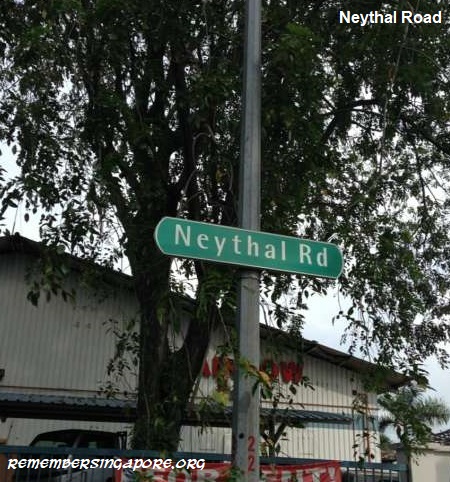 An independent Singapore had a different approach; it now placed importance on a multiracial society. When the new Jurong Industrial Estate was set up in 1968, the roads within the industrial area were appropriately named in Malay or given English names that were translated from Chinese and Tamil. Some examples are Jalan Tukang (Malay), Soon Lee Road (Chinese) and Neythal Road (Tamil).
The Committee on Street Names lasted until 2003 when it was replaced by the Street and Building Names Board (SBNB). The secretariat function of board was handed over, in 2010, from the Inland Revenue Authority of Singapore (IRAS) to the Urban Redevelopment Authority (URA) .
Street Suffixes
For the street suffixes in the street names, Singapore largely follows the British naming convention, which means streets and roads refer to any thoroughfares between two places, ways for major roads, and avenues, lanes, drives, vales, rises and groves are residential roads.
For paved public walkways, they can be named a promenade, esplanade, parade or simply walk if they are along the coast, seafront or river.
![]() The United States (US) has its own set of street suffixes. For examples, it has roads called turnpike (refers to a road where tolls are collected), freeway (dual carriageway with controlled access) and stravenue (used exclusively in the state of Arizona to refer to a road that runs diagonally between and intersects an avenue and a street).
The United States (US) has its own set of street suffixes. For examples, it has roads called turnpike (refers to a road where tolls are collected), freeway (dual carriageway with controlled access) and stravenue (used exclusively in the state of Arizona to refer to a road that runs diagonally between and intersects an avenue and a street).
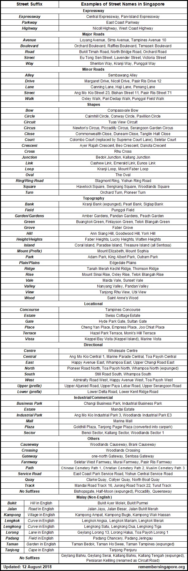
Under the Land Transport Authority (LTA), the types of roads in Singapore fall under five major categories (refer to the right table).
Category 1 Roads (Expressway, Parkway, Highway)
At the top hierarchy of Singapore roads are the expressways and semi-expressways (highways), connecting, in Singapore’s context, between new towns or the city area. Expressways are urban motorways designed for high speed vehicular traffic, with no or few traffic light controlled junctions.
There are currently 10 expressways in Singapore, with the eleventh North-South Expressway (NSE) expected to be completed in 2023. The 10 expressways are the Ayer Rajah Expressway (AYE), Bukit Timah Expressway (BKE), Central Expressway (CTE), East Coast Parkway (ECP), Kallang-Paya Lebar Expressway (KPE), Kranji Expressway (KJE), Marina Coastal Expressway (MCE), Pan-Island Expressway (PIE), Seletar Expressway (SLE) and Tampines Expressway (TPE).
The East Coast Parkway is the only expressway in Singapore named parkway.

Singapore’s semi-expressways are called highways; they are designed with lower speed limits, and unlike the expressways, they have traffic light controlled junctions along their routes. The Nicoll Highway, West Coast Highway and Jurong Island Highway are part of Singapore’s semi-expressway network, which also includes the long parallel Bukit Timah-Dunearn Roads.
The Tuas Second Link Highway is, in fact, a bridge that spans across the Straits of Johor between Singapore’s Tuas and Johor’s Tanjung Kupang.
There was also the Bedok Highway, built by the Public Works Department (PWD) in the mid-seventies, that linked Upper Changi Road to East Coast Parkway. The name, however, lasted only a couple of years before the Committee On Street Names, after consultation with the Housing and Development Board (HDB), decided to change it to Bedok South Avenue 1.

During the renaming process, Bedok Plain, Bedok View and Bedok Walk were also changed to Bedok South Road, Bedok South Avenue 2 and Bedok South Avenue 3 respectively.
Category 2 Roads (Boulevard, Avenue, Way)
The Category 2 refers to the major arterial roads in Singapore. They are named boulevards, avenues and ways, and are typically designed in dual carriageways with a physical median between opposite lanes.
Planted with rows of trees along its sides and median, boulevards are wide roads typically found in the city area. Raffles Boulevard, Temasek Boulevard, Central Boulevard, Marina Boulevard, Republic Boulveard and Straits Boulevard are the examples. Others include Airport Boulevard (Changi Airport), Orchard Boulevard, Stadium Boulevard (Singapore Sports Hub), and Tuas South Boulevard (currently the westernmost road in Singapore).

Avenues, on the other hand, are broad roads flanked by buildings and trees. During the eighties and nineties, the main arterial roads within the new towns, such as Ang Mo Kio, Bukit Batok, Chua Chu Kang, Jurong East, Jurong West, Tampines and Yishun, were named avenues.
Many of the older roads, however, were called avenues but they are actually more of local access roads instead of main arterial roads. This is because the older roads were not bounded by the modern naming convention, or their importance as main roads had declined over the decades due to development.
 Technically speaking, a way is a small side street off the road. In Singapore, the descriptor is widely used for major arterial roads, with the most famous being Shenton Way. Other less significant examples are Loyang Way, Kranji Way and Sunset Way.
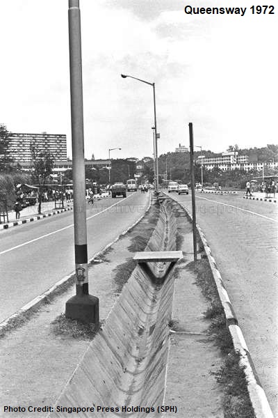
Initially called Queen’s Way, the two words in its name were combined as one, making Queensway one of the few streets in Singapore without any street suffixes.
The first section of Queensway and Queen’s Circus were built in the late fifties, linking Holland Road to the fringe of the newly-developed Queenstown. In the early sixties, Queensway was further extended to Rumah Bomba Circus, where it was connected to Alexandra Road.
Category 3 & 4 Roads (Drive, Road, Street)
Category 3 and Category 4, made up of drives, roads and streets, include the minor arterial roads as well as roads used for primary access. In general definitions, a street is a public road with buildings on both sides, while drives are long winding roads with routes shaped by nearby mountain or lake.
The major roads in Singapore can be named roads, drives and streets, such as Bukit Timah Road, Eu Tong Sen Street, Holland Road, Serangoon Road and Victoria Street.

At the new towns, however, streets and drives often rank below avenues and roads. For example, Bukit Batok West Avenue 5 is the primary road that runs through the Bukit Batok neighbourhood; Branching off Bukit Batok West Avenue 5 are Bukit Batok Street 31 and Bukit Batok Street 52, access roads that lead to the 300-numbered and 500-numbered HDB flats respectively.
Category 5 Roads (Walk, Lane, Link, etc)
The Category 5 consists of secondary roads, minor roads and roads mainly used for local access, which can be single way or dual carriageway of only one or two lanes, without any physical median.
The category is made up of different types of street suffixes such as link, lane, loop and walk. Link refers to road linkages, while close is used for cul-de-sac or dead end roads (which practically is not always true). Loop, crescent and ring typically mean curved roads, whereas a circle is a long curved road that connects from one end to the other end of an estate. Walk is usually used for wide public pedestrian walkways, but in Singapore context, it is also used for minor roads that are for local access.

In a private residential estate, due to the numerous local access roads it may be having, a mixture of name descriptors such as green, garden, place, rise or terrace will also be used. For example, at Bedok’s Eastwood Estate, there are Eastwood Road, Eastwood Drive, Eastwood Green, Eastwood Place, Eastwood Terrace, Eastwood Walk and Eastwood Way.
Likewise, for Springleaf Garden Estate, along Upper Thomson Road, it has a total of 11 local access roads, namely Springleaf Road, Springleaf Avenue, Springleaf Crescent, Springleaf Drive, Springleaf Garden, Springleaf Height, Springleaf Lane, Springleaf Link, Springleaf Rise, Springleaf Walk and Springleaf View.

The naming convention applies to public housing estates too, especially the newer towns such as Sengkang and Punggol. The Sengkang New Town consists of Compassvale Bow, Compassvale Crescent, Compassvale Drive, Compassvale Lane, Compassvale Link, Compassvale Road, Compassvale Street and Compassvale Walk.
Shapes (Square, Circle, Oval, etc)
Street names that have descriptors in shapes, forms and contours are usually based on the configuration of the roads.
For example, Sengkang Square and Woodlands Square are named based on their squarish layouts which border their respective town centres. Sengkang MRT Station, Sengkang Bus Interchange and the Compass One mall are located within Sengkang Square, while Woodland Square forms a squarish perimeter around Woodlands’ MRT station and bus interchange, and the Causeway Point shopping mall.

Other streets that have square as their name descriptors include Flanders Square, off Serangoon Road, and Ellington Square, a private housing estate in Ang Mo Kio. A new Prince Charles Square is also coming up, linking to the existing Prince Charles Crescent off Alexandra Road.
A Circle, on the other hand, describes a long curved road that skirts an estate or vicinity. Cairnhill Circle, Conway Circle (Serangoon Gardens), Pavilion Circle (Bukit Batok) and Lagos Circle (Sembawang) circumscribe their respective private residential estates, whereas Gul Circle is a long boundary road around the large industrial estate at Tuas.
Similar to circle is circus, referring to a roundabout where several streets converge. The Newton Circus is one of the most famous roundabouts in Singapore; others are Serangoon Garden Circus, Piccadilly Circus (Seletar) and Pioneer Circus (Tuas).

Many old roundabouts in Singapore had phased out and were replaced by traffic light controlled junctions. This was because roundabouts often caused traffic confusions that led to accidents. Some of the former circuses that ceased to exist were Alexandra Circus, Delta Circus, Gillman Circus, Hillview Circus, Orchard Circus, Rochor Circus, Princess Circus, Queen’s Circus, Tanglin Circus and Pulau Saigon Circus.
The Rumah Bomba Circus, built in the late fifties, was a large roundabout that linked to Alexandra Road, Queensway and Jalan Bukit Merah. Both Queensway and Jalan Bukit Merah were constructed in the early sixties, a few years after the completion of Rumah Bomba Circus. The roundabout lasted until 1976, when the PWD converted it into a traffic light controlled junction.

The Oval, located in the Seletar vicinity, is a unique name, being the only road in Singapore named after the oval shape. It also has a street prefix of The, which is usually disallowed by the Street and Building Names Board (SBNB) to prevent the impression of the street “monopolising” the area.
The name was retained nevertheless, due to its historical link with the establishment of the Royal Air Force (RAF) Seletar in the late 1920s, when The Oval, along with other British-named roads, were developed as part of the road infrastructure that served the air base and its private residential estate.

In Singapore, there are four roads with the as street prefix. Other than The Oval, there is also The Inglewood at Sin Ming, The Knolls, a small road in Sentosa that leads to Capella Hotel, and The Loop, a minor road previously located between Sembawang Road and Mandai Road but was expunged due to the development of Sembawang Airbase.
Other street name descriptors associated with shapes, forms and contours are bow, circuit, close, court, crescent, cross, junction, loop, ring and turn. Each has its own definition; for example, a court refers to a circle or loop without a throughway, whereas crescent typically describes a curved road that tapers at both ends, much like a semi-circle when viewed from the top. Dakota Crescent and Beo Crescent are two well-known crescent-named roads in Singapore.

Beo Crescent took the name from the nearby Beo Lane, also located off Havelock Road. Beo Lane – Beo means temple in Hokkien and Teochew – was named in 1907 after the three Chinese temples in the vicinity. The temples were burnt and destroyed in the 1961 Bukit Ho Swee Fire, and the road itself was later expunged.
The fire disaster led to the development of new Bukit Ho Swee HDB flats to house the affected residents. Beo Crescent was built at almost the same period. During its construction, some century-old shophouses along Havelock Road had to be demolished, much to the dismay of the residents who had lived there for generations.

In the 2000s, with the addition of a new multi-storey carpark and other amenities, Beo Crescent was altered and cut short. The Beo Crescent of today no longer looks like a curved “crescent” road.
There are many other roads in Singapore that carry crescent as their street suffix, such as Ayer Rajah Crescent, Commonwealth Crescent, Eunos Crescent and Telok Blangah Crescent. An interesting one is called Moon Crescent, but the road, previously located off Upper Changi Road, was expunged during the expansion of the Changi Prison complex.
Topography (Basin, Grove, Ridge, etc)
Topography-related terms are common road name descriptors, often used to describe the terrains and landscapes that are in close proximity to the streets. These include basin, crest, field, garden/gardens, green, grove, height/heights, hill, island, mount, park, peak, plain/plains, ridge, rise, summit, vale, valley and view.
Hill is a common street suffix – there are roads in Singapore named Binjai Hill, Claymore Hill, Goodwood Hill, Leonie Hill, Paterson Hill, York Hill and many others.

Other than the land-related topographic terms, there are also water body-related descriptors used in the street names, such as bay, coast, cove, island and marine.
The island-named roads are all located at Sentosa, where the new private residential developments have named their inner roads Coral Island, Paradise Island, Pearl Island, Sandy Island and Treasure Island.
Locational (Central, Place, Terrace, etc)
The road name descriptors and street suffixes under the locational context include boundary, central, centre, concourse, edge, gate, parade, perimeter, place, point, terrace, town, view, village and vista. Also, at designated industrial, commercial and business parks, the inner roads can be named business park, estate, industrial park, mall, plaza or sector. For instances, there are roads named Ang Mo Kio Industrial Park 3 and Woodlands Industrial Park E3 within the Ang Mo Kio and Woodlands industrial parks respectively.
 Directional descriptions are a part of the street suffixes with locational context. They can be east, west, north, south, central, upper and lower. The last two are actually street prefixes instead of suffixes.
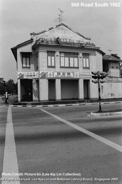
Upper Changi Road East, Admiralty Road West, Pioneer Road North and Still Road South (formerly Karikal Road) are the extensions of the main road – Upper Changi Road, Admiralty Road, Pioneer Road and Still Road.
Directional suffixes can also be found in some of the older housing estates. When Toa Payoh was developed in the mid-sixties, its main roads were simply named Toa Payoh East, Toa Payoh West and Toa Payoh North. A flyover called Toa Payoh South Flyover was later built to link to the Pan-Island Expressway (PIE). Likewise, there are Whampoa East, Whampoa West, Whampoa North (expunged) and Whampoa South.
In some cases, street prefixes of upper and lower are used instead, such as Upper Paya Lebar Road, Upper Serangoon Road and Lower Delta Road, to indicate the continuation of, in these examples, Paya Lebar Road, Serangoon Road and Delta Road.
Non-English (Jalan, Lorong, etc)
A large number of roads in Singapore are named in Malay. Both jalan and lorong generally refer to roads in English. Non-English names for streets, however, are not encouraged anymore after the 2000s with the establishment of the SBNB.
The better known jalans are Jalan Besar, Jalan Kayu, Jalan Bahar, Jalan Ampas, Jalan Bahagia and Jalan Ahmad Ibrahim. Some jalans have incorporated Chinese dialect names, such as Jalan Tua Kong, off Upper East Coast Road, and the expunged Jalan Ang Siang Kong, off Tampines Road, where the Golden Palace Resort once stood.

Sometimes, the road names could be so long that they were shortened in maps and street directories. Jalan Gagak Selari Timor and Jalan Gagak Selari Barat, the extensions of Jalan Bukit Merah, became Gagak Selari Timor and Gagak Selari Barat on the maps, before they were, in the seventies, renamed Jalan Bukit Merah and became part of the entire stretch of the road.
While most other new towns named their roads avenues, streets and drives, Toa Payoh, Singapore’s second satellite town, largely use lorongs for its road names. Within the town are Toa Payoh Lorong 1, 2, 3, 4, 5, 6, 7 and 8.
 Another vicinity with many lorongs is Geylang, where the odd- and even-numbered lorongs are located on both sides of Geylang Road.
In 1980, there were suggestions to the Advisory Committee on Street Names that all the jalans and lorongs in Singapore be renamed to English’s roads and avenues. Fortunately, this was rejected by the committee, as it was deemed that the original names could better reflect the heritage of the streets. Also, the names of the streets were already familiar to most Singaporeans, and any alterations would cause inconvenience and confusion.
Like the jalans, there are lorongs assigned with Chinese dialect names, such as Lorong Lew Lian and Lorong Ong Lye at the Upper Serangoon vicinity, possibly named after the durian and pineapple plantations there in the olden days.
Other Malay street suffixes are bukit (hill), kampong (village) padang (field), taman (garden/park) and tanjong (cape). There are only a handful of such roads. Bukit Ayer Molek (near Bukit Timah Nature Reserve), Padang Jeringau (off Kallang Road), Padang Chancery (off Thomson Road), Taman Bedok (off Bedok Road), Taman Ho Swee (at Bukit Ho Swee estate) and Tanjong Penjuru are some of the examples.
The lengkongs (curve/crescent in Malay) can be found within the Kembangan district, where there are Lengkong Satu, Lengkong Dua, Lengkong Tiga, Lengkong Empat, Lengkong Limi, Lengkong Enam and Lengkong Tujoh (Tujuh), named after the numbers one to seven. Lengkok also means curve/crescent in Malay – there are Lengkok Angsa, Lengkok Mariam, Lengkok Merak.

One unique Malay-named road was Persiaran Keliling at MacPherson housing estate, where the road formed a loop around the HDB flats built in the sixties. It was renamed Circuit Road in the early seventies.
Roads that had street suffix of kampong were usually the main roads to the villages they named after, for example Kampong Bugis, Kampong San Teng (expunged), Kampong Wak Hassan and Kampong Wak Tanjong (expunged).
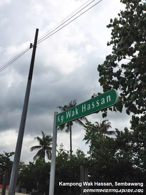
Kampong Wak Hassan is located at the end of Sembawang Road. The Malay village Kampong Wak Hassan was demolished in the nineties, but the road name stays on. In the vicinity, there are other minor roads named after the village, such as Wak Hassan Drive and Wak Hassan Place.
Types of -way
Beside expressway, parkway and highway, there are other roads in Singapore that use -way as their name descriptors, such as causeway, gateway and farmway.
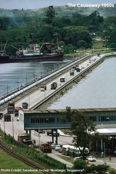 Causeways are raised roads above a broad body of water or wetland. The Causeway, also known as Woodlands Causeway or Singapore-Johor Causeway, was opened in 1923, forming a 1.05km link between Singapore and Johor Bahru.
At the south of Singapore are the Brani Causeway (links to Pulau Brani) and Sentosa Gateway (links to Sentosa). The latter is the vehicular link to Sentosa, which was opened in December 1992 as a 380m-long causeway. The second causeway to Sentosa is a bridge, built in 2009 by the Resorts World Sentosa (RWS), serving as an one-way incoming route to the island.
Gateway can also be used to refer to start-point or entrance, at strategic locations, to a district. One example is the new one-north Gateway near Fusionopolis.
The farmways, uniquely named in Singapore, once refer to the rural tracks that led to the vegetable, poultry and pig farms located at the northeastern and northwestern parts of Singapore.

Previously, there were Seletar East Farmway, Punggol Farmway, Cheng Lim Farmway, Buangkok North Farmway and Buangkok South Farmway, but all of them were expunged during the development of the Sengkang and Punggol New Towns in the late nineties and early 2000s. Today, the only farmways still exist in Singapore are the Seletar West Farmway, Pasir Ris Farmway and Murai Farmway (Lim Chu Kang).
Others
Other rural roads, simply named tracks, used to be found along major roads such as Mandai Road, Punggol Road and Yio Chu Kang Road. They were long muddy trails that provided accessibility to the villages, farms and plantations. Most had been expunged, with a few like Jurong Road Track 22, Mandai Road Track 16 and Old Choa Chu Kang Road Track 14 still manage to survive till today.

At the Choa Chu Kang cemetery sites, the roads leading to the different sections of burial places are named paths, such as Admadiyya Cemetery Path 1, Chinese Cemetery Path 7, Christian Cemetery Path 2, Hindu Cemetery Path 1 and Muslim Cemetery Path 10.
For roads with street suffix of quays, they are largely located in the downtown or by the sides of the Singapore River. Examples are Boat Quay (converted into pedestrian walkway), Clarke Quay, Collyer Quay, North Boat Quay, Raffles Quay and Robertson Quay.

Without Street Suffix
Only a few roads in Singapore have no street suffixes. Most were located at the old Seletar vicinity. Half-Moon, a short curved road, was expunged when Seletar Aerospace was developed. There were also Chowringhee (named after a place in India), Haymarket and Knightsbridge (both named after places in Britain), roads that were lost during the changes in Seletar in the past few decades.
Today, the roads without street suffixes are Bishopsgate (Tanglin), Piccadilly (Seletar) and Queensway. Off Bishopsgate was a short lane named Bishopswalk. but it was absorbed into the premises of private condominium Bishopsgate Residences upon its completion in 2012.

One and Only
Some of the street suffixes have only been used once, such as alley (Sembawang Alley), bow (Compassvale Bow), concourse (Tampines Concourse), field (Punggol Field), grande (Tampines Grande), ring (Stagmont Ring) and wood (Saint Anne’s Wood).
Meanwhile, Seletar Court, off Yio Chu Kang Road, is the only court-named road after Colombo Court was replaced by Supreme Court Lane. Although Cross Street is a well-known road, Rhu Cross is the only road with street suffix of cross. But the road itself is a straight road instead of a cross-like junction.
At Woodlands Checkpoint, the inner lanes are named Woodlands Crossing, the only set of roads in Singapore with crossing as its street suffix. And Kim Seng Promenade, the curved road between Great World City and Singapore River, is the only road named promenade.
Summary
Published: 15 August 2018
Updated: 18 February 2020
Discover more from Remember Singapore
Subscribe to get the latest posts sent to your email.


Hi, just wondering what would the roads
Punggol Seventeenth/twenty-fourth Avenues be classified under? Not sure if you may have missed it.
Cheers!
By right, their street suffixes are avenues, but the modern street naming convention (Avenues now largely refer to major arterial roads) does not apply to the roads built decades ago. Ponggol Seventeenth Avenue and Ponggol Twenty-Fourth Avenue were built in the ’70s as proper roads leading to new private residences (it’s also likely to differentiate them from the main Punggol Road and its rural tracks – Punggol Road had Track 1 to Track 26 back then).
Lengkong Satu till Tujoh actually means “Cape” in Malay. I myself have documented all of the Malayan street names in Singapore. Check out my blog!
Comprehensive list!
BTW can Tekong Highway, which seems to be the only major road in Pulau Tekong and connects all the camps and key installations within Pulau Tekong, be considered as a semi expressway?
Probably on Tekong context. If based on mainland Singapore, it is at best a major road.
Regarding Beo Crescent… do you know more about the temples in that area? Currently, there are two temples along Havelock Road: the smaller one near Kim Seng CC is dedicated to Tua Pek Kong (affiliated to Kusu Island), the other one is at the junction of Zion Road, a bigger one dedicated to the Jade Emperor and and assortment of other deities.
Blk 29 along Havelock Road has also been demolished not too long ago, you can see the outlines on the ground a building which used to be there. Google Maps street view shows the change. There’s also a small ‘Isetan’ building next to it which still stands.
In addition, there are also Bahtera Track (track) and Sarimbun Dyke and Poyan Dyke (dyke), all of which are located at the western water catchment area.
For Bahtera Track, can refer to https://remembersingapore.org/2016/07/17/sarimbun-beach-landing-jalan-bahtera/
Serangoon Garden Way is a Cat. 2, Cat 3 or Cat 4 Road ?