The first blueprint of Singapore’s expressway network began in 1968, when it was mapped out as part of the State and City Planning Project. The authorities recognised that expressways were the best method to provide better and faster travel in the land-scarce Singapore.
Before the completion of the Pan-Island Expressway (PIE) in 1981, it was unimaginable to drive from the Changi Airport to the end of Jurong in under 45 minutes. The road network then was made up of the major roads (Bukit Timah Road, Jurong Road, Upper Changi Road, Mandai Road, Tampines Road, Punggol Road, etc) that were marked by milestones, an old system that found its roots in Singapore since the 1840s.
 Expressways would significantly improve the traffic conditions and travel time; an estimate of 1,800 to 2,000 vehicles could move along an expressway lane per hour.
Dual three-lane carriageways were the preferred initial designs, although several upgrading and widening projects in the 2000s and 2010s meant that some of the current expressways have more than three or four lanes to resolve the traffic congestion issues; for example, there are upgraded six-lane carriageways for PIE towards the Adam Flyover exit.
Today, Singapore has a total of ten expressways. They are PIE, East Coast Parkway (ECP), Central Expressway (CTE), Bukit Timah Expressway (BKE), Ayer Rajah Expressway (AYE), Tampines Expressway (TPE), Kranji Expressway (KJE), Seletar Expressway (SLE), Kallang-Paya Lebar Expressway (KPE) and Marina Coastal Expressway (MCE). The eleventh North-South Expressway (NSE) is expected to be completed in 2023.
Except for KPE and MCE, the naming of the Singapore expressways is derived from the first letter of the first two syllables followed by the first letter of the last word. Therefore, for examples, Ayer Rajah Expressway is known as AYE instead of ARE, and Bukit Timah Expressway is called BKE, not BTE (although it was initially named BTE when it was planned in the early eighties).
1. Pan-Island Expressway (PIE)
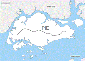 At 42.8km long, PIE is currently Singapore’s longest expressway, spanning across the island from Changi to Tuas.
It is also the oldest expressway in Singapore, having first started in its construction by the Public Works Department (PWD) in 1966 as a mean to link up the existing and new satellite towns and industrial estates between Toa Payoh and the Kallang Basin. This included the widening of Whitley Road from Mount Pleasant to Jalan Kolam Ayer and Paya Lebar Way.
The early seventies saw the continued extensions of PIE. Toa Payoh Flyover and Thomson Flyover were built in 1970 and 1971 respectively. Part of Jalan Toa Payoh became integrated with the expressway, and more than 1,700 graves at Bukit Brown Cemetery were exhumed to make way for the construction.

The second and third phase of PIE were subsequently completed in 1975 and 1980. Towards the west, the expressway was extended to Jalan Anak Bukit, and at the east side, PIE was stretched from Jalan Eunos to Changi. PIE was considered completed when the extension from Jalan Anak Bukit to Corporation Road finished in 1981. By then, it was about 35km long and had 21 flyovers and one viaduct.

In the nineties, PIE was further extended to connect to the new KJE. It also linked up with the AYE, which itself was extended westwards to create a direct route to the newly-opened Tuas Second Link.
Currently PIE is linked to all other expressways in Singapore with the exception of SLE. It is also the expressway with the most number of flyovers – 31 in total – in Changi Flyover (linked to ECP), Upper Changi Flyover (linked to TPE), Simei Flyover, Tampines South Flyover, Bedok Reservoir Flyover, Bedok North Flyover, Eunos Flyover, Paya Lebar Flyover, Aljunied Flyover, Aljunied West Flyover (linked to KPE), Woodsville Flyover, Whampoa Flyover (linked to CTE), Kim Keat Flyover, Toa Payoh South Flyover, Thomson Flyover, Mount Pleasant Flyover, Adam Flyover, Eng Neo Flyover, Chantek Flyover (linked to BKE), Anak Bukit Flyover, Clementi North Flyover, Toh Tuck Flyover, Toh Guan Flyover, Jurong East Flyover, Bukit Batok Flyover, Hong Kah Flyover, Tengah Flyover (linked to KJE), Bahar Flyover, Nanyang Flyover, Pasir Laba Flyover and Tuas Flyover (linked to AYE).

In 1979, the construction of PIE towards Changi was temporarily suspended due to the collapse of the 4.8m-tall Eunos Flyover. A crack was found in the concrete structure that eventually led to the flyover’s collapse. It took more than a year in the investigations and reconstruction before a new flyover was erected. Another similar mishap occurred in 2017 when a PIE’s viaduct near Upper Changi Coast Road collapsed, resulted in one death and 10 injuries.

Fun Trivia: PIE’s exit (26A) to Dunearn Road/Clementi Road is the only rightmost lane exit designed on a Singapore expressway.
2. East Coast Parkway (ECP)
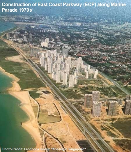
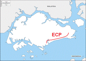 The construction of ECP began in the early seventies on the reclaimed lands of the southeastern coast of Singapore. Taking almost a decade to complete, the coastal expressway was opened in 1981, the same year as the Changi Airport.
ECP is the only expressway in Singapore named a “parkway”. Its western end was originally linked, via the majestic Benjamin Sheares Bridge, to AYE near Shenton Way. In 2013, ECP is no longer directly linked to AYE after the opening of the new MCE underground tunnels.
Named after the second President of Singapore, 1.8km-long Benjamin Sheares Bridge was opened in September 1981 at a construction cost of $110 million. Being the longest and tallest bridge ever built by PWD, the splendid views of the Singapore skyline charmed many motorists so much that, when the bridge was opened, many cars stopped by the sides of the bridge for the scenery and photo takings.

The Benjamin Sheares Bridge was downgraded from part of an expressway to an arterial road after the opening of MCE.
The opening of ECP eased the increasing traffic congestion issues at the city area in the eighties. For instance, the traffic volume at Nicholl Highway had lowered by 20% during the peak hours, and Robinson Road and Cecil Street were better managed with lesser traffic jams.

Much of ECP is flanked on both sides by mature tropical trees and palm trees. Towards Changi Airport, motorists will also pass by a scenic stretch where rows of beautiful potted plants make up the median strip. The hundreds of removable potted plants used to function as an emergency landing runway, but it had never been used or tested, and its secondary function had since been decommissioned.
Serving as a fast route from the airport to city area, the new Changi Airport and the well-landscaped ECP with colourful bougainvilla blooms and other shrubbery gave many visitors and tourists a good impression of Singapore as soon as they landed in the country.

ECP has Changi Flyover (linked to PIE), Tanah Merah Flyover, Laguna Flyover, Marine Parade Flyover, Tanjong Katong Flyover and Tanjong Rhu Flyover, running past the residential districts of Bedok South, Marine Parade, Siglap, Katong and Tanjong Rhu.
Fun Fact: In 1998, ECP became the first expressway to be tested and installed with Electronic Road Pricing (ERP) gantries.
3. Bukit Timah Expressway (BKE)
 Completed in the mid-eighties, BKE runs from north to south, providing the link between Woodlands and PIE. At its northern end, it joins directly to the Woodlands Custom and Causeway. Along its 11km-long route, the expressway is connected to three other expressways in SLE, KJE and PIE.
The opening of BKE – it was initially known as BTE – at the end of 1985 provided much convenience and accessibility to the Woodlands residents who needed to get to their workplaces at the southern and western sides of Singapore. Likewise, the newly developed Woodlands got a boost as it became easier to reach the new town from other parts of Singapore.

The construction of BKE began in 1983 in two stages – Woodlands to Mandai Road, and then Mandai Road to PIE. The step-by-step construction of the expressway and the changing landscape of its surroundings were, for the first time, recorded in a 30-minute filmlet.
The project also saw one of the largest land acquisitions in the eighties – more than 2.8 million square metres of private lands at Bukit Timah, Mandai and Sembawang were acquired by the government for national development. Almost half of the lands acquired were owned by the family of local tycoon and hotelier Khoo Teck Puat (1917-2004).

Designed with six-lane dual carriageways, the expressway has seven flyovers – Woodlands Flyover, Mandai Flyover, Gali Batu Flyover, Zhenghua Flyover, Dairy Farm Flyover, Rife Range Flyover and Chantek Flyover. In 2003, a section of BKE was converted into four-lane dual carriageway for better linkage to SLE.
Fun Fact: Spanning over BKE near Rifle Range Road is the Eco-Link @BKE, a 62m-long bridge built just for wildlife, the first of its kind in South-east Asia. With its opening in 2013, Bukit Timah Nature Reserve and Central Catchment Nature Reserve are linked once again, allowing animals to cross over to either sides.
4. Central Expressway (CTE)
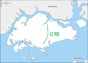 CTE connects the northern and central parts of Singapore to the city area, running through numerous new towns in Ang Mo Kio, Bishan and Toa Payoh. At the north, it is linked to SLE and TPE, and AYE at the Radin Mas Flyover at its southern end.
By the mid-eighties, Singapore had two completed expressways in PIE and ECP. In addition, the first phases of the construction of CTE, AYE and BKE had commenced. Four more expressways – Seletar Expressway (SLE), Tampines Expressway (TPE), Kranji Expressway (KJE) and Kallang Expressway (KLE) – were planned to link the major areas of activities and allow more rapid travels across the island. A total of nine expressways, at 134km long, was targeted to be part of a developed road network in conjunction with the new transport system in the Mass Rapid Transit (MRT).
Before CTE came into the picture, a Sembawang Expressway was proposed. Running from Nee Soon, via Ang Mo Kio Avenue 1, to Jalan Toa Payoh, it would then be connected to CTE, which started from Jalan Toa Payoh and ended at Lower Delta Road. The plan, however, did not materialise, as CTE was later designed and built as the main expressway between Yio Chu Kang Road and the city area.

The CTE project had three phases. The first phase was to construct an expressway from Yio Chu Kang Road to Bukit Timah Road. This section of CTE was completed in the late eighties and officially opened on 17 June 1989.
Its second phase was to link to AYE at Radin Mas, starting from Chin Swee Road at the Chinatown area. The final stage of the CTE project was also the most difficult in its construction. Two tunnels, Singapore’s first expressway tunnels, under Orchard, Fort Canning, the Singapore River and Outram were built to link the first and second sections of CTE together.

CTE was completed in 1991, reaching a total of 15.5km in length and $500 million in cost. The expressway has 12 flyovers, starting from Seletar Flyover (linked to SLE and TPE) to Yio Chu Kang Flyover, Ang Mo Kio North Flyover, Ang Mo Kio Central Flyover, Ang Mo Kio South Flyover, Braddell Flyover, Whampoa Flyover (linked to PIE), Moulmein Flyover, Kampong Java Flyover, Outram Flyover, Bukit Merah Flyover and ending at Radin Mas Flyover (linked to AYE).

In the late 2000s, projects to widen CTE were carried out to ease the persisting congestion problems, due to the residential development in the northern and northeastern parts of Singapore.
Fun Fact: CTE was the first expressway tunnels in Singapore, and the first expressway to be charged with evening ERP (since 2005).
5. Ayer Rajah Expressway (AYE)
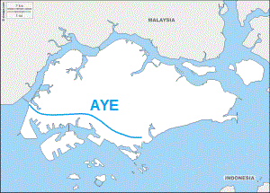 Originally named Jurong Expressway, the plan was to build another coastal expressway, similar to ECP, along West Coast. The new expressway was later named AYE instead, after Ayer Rajah Industrial Estate which was developed by the Jurong Town Corporation (JTC) in the early seventies.
The AYE project, comprising of a length of 14km at the start, was carried out in two phases – a Keppel Viaduct between ECP and Kampong Bahru Road, and the upgrading of the existing Ayer Rajah and Upper Ayer Rajah Roads to become parts of the new expressway.

The Keppel Viaduct, standing on 60 spans, was completed in 1985 after two years of contract tenders, planning and construction. Costing $60 million, the 2.1km-long viaduct, with its dual three-lane carriageways, was built to ease Keppel Road, congested with almost 3,000 vehicles during the peak hours.
The second phase of the AYE project was the conversion of Ayer Rajah Road and Upper Ayer Rajah Road, two existing roads that laid down as the foundation routes for the expressway. Ending at Jurong Town Hall Road, the construction of AYE was by 1988 fundamentally completed. The ECP-AYE link had become the second east-west route in Singapore after PIE.

In 1994, AYE was further extended to the western side of the island to connect to the new Tuas Second Link, with Jalan Ahmad Ibrahim upgraded to become a section of the expressway. The extension project was eventually concluded in 1998, stretching AYE to a total of 26.5km in distance.
There is a total of 16 flyovers along AYE – Kampong Bahru Flyover, Radin Mas Flyover (linked to CTE), Lower Delta Flyover, Henderson Flyover, Gillman Flyover, Portsdown Flyover, Buona Vista Flyover, University Flyover, Clementi Flyover, Pandan Flyover, Teban Flyover, Corporation Flyover, Jurong Hill Flyover, Pioneer Flyover, Benoi Flyover and Tuas Flyover. In addition, AYE also has an underpass (Tuas West Underpass) and another viaduct (Tuas Checkpoint Viaduct).

Fun Fact: The Keppel Viaduct, with Keppel Road running underneath it, was the first two-tier road system in Singapore.
6. Tampines Expressway (TPE)
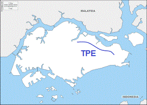 Tenders were called in 1986 to build the first phase of TPE, which at the start stretched from PIE at the eastern side of Singapore to Elias Road.
The project included the conversion of a 4km-long section of Tampines Road into an expressway of dual three-lane carriageways, and the building of a large interchange that linked Loyang Avenue, Upper Changi Road East and Tampines Avenue 7.
In September 1987, TPE became Singapore’s sixth expressway when its completed section was opened to traffic. The same year saw its second phase of construction kicked off – the continuation of the expressway westwards from Elias Road to Lorong Halus. The second extension was completed and opened by May 1989.


The third stage of TPE, linking between Lorong Halus and CTE, finished in 1995, although the 8km-long final section was opened only a year later. Overall, it took nine years and $125 million to build the 14.5km-long TPE.
The construction of TPE coincided with the development of Tampines New Town in the eighties. When it was fully completed in the mid-nineties, TPE, however, was the least utilised expressway, as it cut through the largely rural northeastern parts of Singapore. TPE’s usage rate only increased after the new towns of Sengkang and Punggol became more developed in the late nineties.

In 2008, TPE was linked to KPE near Lorong Halus, when the new underground expressway opened after six years of construction. Currently, there are 11 flyovers along TPE – Upper Changi Flyover (linked to PIE), Loyang Flyover, Pasir Ris Flyover, Api Api Flyover, Tampines Flyover (linked to KPE), Punggol East Flyover, Punggol Flyover, Punggol West Flyover, Seletar Aerospace Flyover, Jalan Kayu Flyover, Seletar Flyover (linked to CTE and SLE).
Fun Fact: Api Api Flyover was named after the nearby Sungei Api Api. The river itself was named after Api Api (mostly Avicennia alba), a type of tropical mangrove growing along the river banks that attracts fireflies. Api means fire in Malay.
7. Kranji Expressway (KJE)
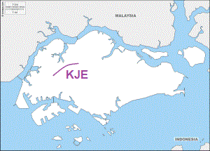 The construction of KJE began in 1990, as part of the government’s plan to develop the northwestern part of Singapore into vibrant residential and industrial districts.
At 8.4km long, the construction took about five years; some kampongs at old Choa Chu Kang such as Kampong Cutforth, and several long dirt tracks had to make way for the construction of the expressway. KJE was eventually inaugurated in March 1995.
KJE, linking between BKE and PIE, provided a more convenient and direct route for the residents of Choa Chu Kang, Bukit Batok, Jurong and Bukit Panjang to commute between Woodlands and the western side of Singapore.
KJE currently has five flyovers – Gali Batu Flyover, Yew Tee Flyover, Choa Chu Kang East Flyover, Choa Chu Kang West Flyover, Lam San Flyover and Tengah Flyover.
Fun Fact: KJE is one of the first roads in Singapore to be built with anti-skid surfacing.
8. Seletar Expressway (SLE)
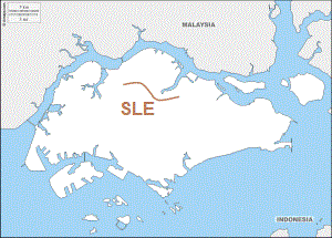 Built in two phases, from 1992 to 1998, the 12-km SLE links with TPE and BKE at both ends, and also CTE at Yio Chu Kang area.
The first phase of the SLE project was carried out between Yio Chu Kang Road and Upper Thomson Road, whereas the second phase was more complicated, as it included the construction of the expressway from its interchange with BKE to Upper Thomson Road via Woodlands and Mandai. The final stage of SLE was eventually wrapped up in 1998, and the new expressway had an official opening on 22 February by the Minister of State John Chen.

There are seven flyovers for SLE – Woodlands South Flyover, Marsiling Flyover, Ulu Sembawang Flyover, Upper Thomson Flyover, Lentor Flyover, Seletar Flyover and Yio Chu Kang Flyover
The completion of SLE in 1998 meant that the loop was closed at the northern part of Singapore, and the country’s expressway network was considered fully connected. This provided greater convenience for the residents of Woodlands, Sembawang and Yishun.

Fun Fact: The construction of SLE resulted in the largest clearance of roads. Lorong Gambas, Lorong Handalan, Lorong Lentor, Lorong Selangin, Lorong Hablor and many other roads and dirt tracks were expunged.
9. Kallang-Paya Lebar Expressway (KPE)
 When Singapore’s ninth expressway KPE was opened in September 2008, it smashed several records. At 9km, it was the longest underground road in Singapore as well as Southeast Asia. It was also the most challenging and expensive road project undertaken by the Land Transport Authority (LTA), topping $1.7 billion in total construction cost.
KPE was actually made up of Kallang Expressway (KLE) and Paya Lebar Expressway (PLE), two expressway concepts that were mooted by the government in the late sixties and mid-eighties respectively. KPE itself was planned as early as 1991, but the massive project only kicked off in 2001 after the government acquired lands at Geylang, Airport Road and Upper Paya Lebar Road.

Due to its underground tunnels, KPE is fitted with several facilities, such as a 24/7 operation control centre to monitor the traffic conditions, heat detectors, fire alarms, carbon dioxide sensors and ventilation exhaust systems. KPE is 12km long, inclusive of 3km surface roads and 9km underground tunnels. It is linked to three existing expressways – TPE at the north, PIE, and ECP at its southern end.
Fun Fact: KLE was supposed to be a 3km-long link that began from PIE near Sims Avenue and Geylang Road, and soared over Nicholl Highway, Mountbatten Road and Fort Road to link up with ECP in the south. It would be the shortest expressway in Singapore if it was built.
10. Marina Coastal Expressway (MCE)
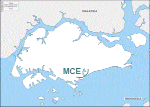 MCE’s construction began in 2008 as one of LTA’s most ambitious projects. At $4.1 billion, it is currently Singapore’s most expensive expressway. The dual five-lane expressway, 5km long with a 3.6km underground tunnel, was officially opened in December 2013.
Functioning as a link between ECP and AYE, the expressway has the widest and deepest underground road tunnel in Singapore. During construction, almost 3 million cubic metres, about the size of 1,200 Olympic swimming pools, were excavated. Part of MCE is a 420m-long section under the Marina Bay Channel, the first such underground sea tunnel built for vehicles in Singapore.

The completion of MCE also downgraded the Benjamin Sheares Bridge from an expressway viaduct to an arterial road.
Fun Fact: The word “coastal” was added to the name MCE to better reflect its route along the southern coast of Singapore in the Marina area.
11. North-South Expressway (NSE)
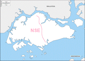 NSE’s role is to provide residents and motorists living in the north with a high speed and time-saving link to the city area, at the same easing CTE’s congestion issues. Its planned connections to the SLE, PIE and ECP are also expected to enhance the overall efficiency of Singapore’s expressway network.
The 21.5km-long expressway will also become the first integrated transport corridor in Singapore, designed with continuous bus lanes, for express bus services between Sembawang, Woodlands, Yishun, Ang Mo Kio and the city area, as well as designated cycling routes that are connected to the Park Connector Networks (PCN).
The newest expressway is expected to be completed in 2023, at a recorded construction cost of $7 billion.
Published: 29 April 2018
Discover more from Remember Singapore
Subscribe to get the latest posts sent to your email.


The only right-turn expressway exit in Singapore will officially walk into history soon…
Right-turn exit on PIE to be replaced with new left exit on May 28
14 May 2023
The Straits Times
From 5am on May 28, Singapore’s only right-turn expressway exit, located on the Pan-Island Expressway (PIE), will be replaced by a new left exit.
The Land Transport Authority (LTA) gave the date of PIE Exit 26A’s relocation in a statement on Sunday after the move was twice delayed. Construction on the $32.7 million project began in February 2018.
With the new exit, motorists on the westbound PIE turning off towards Dunearn Road, Clementi Road and Upper Bukit Timah Road will be led to a downward ramp on the left, which links to the new Rifle Range underpass running underneath the expressway.
The 90m-long underpass will connect back to the existing slip road on the other side of the expressway leading to Jalan Anak Bukit.
LTA told The Straits Times that the move will help to improve traffic flow and safety on the PIE.
“We do not expect significant changes in commuting time,” said its spokesman.
Signs will be put up two weeks before the opening of the new exit to inform motorists of the upcoming change. Traffic marshals will also be deployed during peak hours on the first few days after opening.
https://www.straitstimes.com/singapore/transport/right-turn-exit-on-pie-to-be-replaced-with-new-left-exit-on-may-28