
During the Japanese Occupation, the Japanese constructed two of their sacred sites in Singapore. One was the Syonan Chureito at the top of Bukit Batok Hill, while the other was the better-known Syonan Jinja at MacRitchite Reservoir.
The Syonan Jinja – its name means “Light of the South Shrine” – was a Shinto shrine built to commemorate the Japanese soldiers who died in Malaya during the Second World War. Designed based on Tokyo’s Yasukuni Shrine, the construction of Syonan Jinja started in April 1942, two months after the fall of Singapore.


Under the command of Major Yasuji Tamura, the officer-in-charge of the Japanese Army’s 5th Division Engineers Regiment, almost 10,000 British and Australian prisoners-of-war (POWs) from the internment camps of Changi, Sime Road and Adam Park were forced to carry out the hard labour, including the clearance of a section of the heavily forested area at MacRitchite Reservoir, construction of a “divine” bridge across the waters, and the building of a flight of 94-step granite steps that led to the shrine.
In May 1942, the foundation stones of the shrine were laid by the notorious “Tiger of Malaya” Lieutenant-Colonel Tomoyuki Yamashita. The Syonan Times, the propaganda newspaper established by the Japanese, publicised the news of the grand ceremony that had many dignitaries and guests invited.


Syonan Jinja was dedicated to Amaterasu Omikami, the goddess of the sun in the Shinto religion and whom the Japanese emperors were said to be direct descendants of.
At its entrance was the “divine” bridge. After crossing the waters, the worshipers would pass through the torii gate before accessing the flight of steps to get to the three 4.5m-tall stone platforms where the open-sided temples stood. Outside the temples was a granite fountain, for purification and cleansing purposes, where it had water drawn from the reservoir through a pump and filtration system.


Upon its completion at the end of 1942, the shrine’s site occupied approximately 470 acres, or about 1.9 square kilometres, in size. There were further plans to expand the premises of the shrine to eventually become a Japanese park with gardens, playgrounds and even a stadium for sporting events. Part of the funds were raised through donations, often with sense of intimidation, from sources such as the Overseas Chinese Associations at the various Malayan states.
The Syonan Jinja had a grand opening on 15 February 1943, a year after the fall of Singapore. Shigeo Odate, the first mayor of Syonan, officiated the opening. Japanese military leaders made up the list of distinguished guests, while local community leaders and businessmen were compelled to attend the opening ceremony to show their loyalty and respect.

During the Japanese Occupation, there was also a Kashima Jinja, a branch of Syonan Jinja, built at Pulau Blakang Mati (present-day Sentosa). It was constructed by the POWs imprisoned on the island, and was enshrined on 8 June 1943.
In the later parts of the occupation, Syonan Jinja and Syonan Chureito became important places for public ceremonies and celebrations of Japanese traditional festivals, mostly attended by the Japanese military and civil officials. Most locals steered clear of the place, although students and young people were often forced to participate in the events as a display of their allegiance to the Japanese empire. The Syonan Times reported that the shrine had almost 240,000 visits between 1943 and 1944, although this number might be exaggerated.

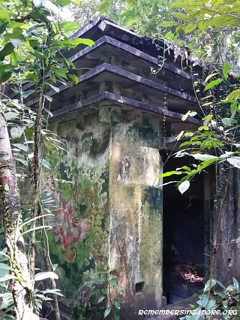
The imminent defeat in 1945 saw the Japanese burnt and destroyed Syonan Jinja, out of fears that the returning British would commit sacrilege on their sacred shrine. The timber portions of the shrine complex were burnt completely, including the bridge. What left behind were the granite and concrete structures, slowly forgotten and consumed by nature over the decades. Today, besides the remnants of the structures, the remains of the bridge foundations in the waters can still be seen.
Along with the Merdeka Bridge and a colonial house at Adam Park, the ruins of Syonan Jinja was declared as a historic site by the National Heritage Board on 16 September 2002, adding a list of 65 historic sites marked since 1996.


Published 16 July 2017
Discover more from Remember Singapore
Subscribe to get the latest posts sent to your email.


The shrine looks like a kampong house. Is that to fit the southeast asian theme?
Reblogged this on Re:HKSF.
I read on the nparks website recently that the area is now officially out of bounds to the public and one is liable for a hefty fine if caught. Did you still manage to get there without any problems? I’ve been wanting to explore this place for the longest time!
Hey! My friend and i just ventured into the dense forest on 19 november 2017, it was a really rough journey and we slowly tracked our way into the GPS point on google map named ‘ syonan jinja’. Unfortunately, we were unable to find any landmarks or buildings that were suppose to be from syonan jinja. As the weather was getting worst, we had to leave. So overall, i don’t think the buildings are there(or it could just be we couldn’t find it). Well, in any case, if you’re planning an adventure to this spot, we can go together!
The granite basin as well as the foundation steps are still there. I think it’s just that you guys didn’t find it.
the trail is closed by nparks due to alot of fallen trees. & hazardous dead fall. if you follow it, it is very likely you will go off trail at some point. hell lot of bashing required if you go off trail & wander into vegetation. aim to walk from solid growing tree to solid tree, in the correct general direction. the ground around such tall solid trees tend to be firmer & therefore with less thorny shrubs
safer only to go if you have basic navigation skills & a compass. trail head starts around the bend of terentang trail, hidden just behind dead fall & marked by a do not enter sign post. the opposite trail end starts near sime track near petaling hut. some swappy soil near the halfway mark to the shrine. definitely avoid wet season
start early on a day with good weather. bring a general map (http://joyloh.com/blog/wp-content/uploads/6024795931_951f1e12c3_b.jpg), compass & a pacer. bring a hiking stick to brush aside throny shrubs. wear long thick pants. watch for dead fall & thorns
not for the regular singaporean
Hi explorer, is your link still functioning? Thank you in advance. Cheers
ww2 treasures were buried in that jungle vast amount 2,000 tons of gold
My Dad and Sergeant Clarke from the Greenjackets found a ton of it in 1956.
I went there many times when I lived in Singapore. Last time some 7 years ago I think. Yes, some hiking off the beaten track for sure.