Built between the 1870s and 1890s, Fort Serapong, together with Fort Siloso, Fort Connaught and the Imbiah Battery, formed an integrated part of the British’s southern coastal defence at Pulau Blakang Mati (present-day Sentosa). The fortifications, along with Fort Pasir Panjang on the southern part of mainland Singapore, were aimed to protect the colony’s flourishing port, possibly against the Dutch East Indies, pirates or other enemies.

The forts were not the first fortifications built by the British against sea attacks. Fort Fullerton, located at the mouth of the Singapore River, was built in 1830 to defend the town of Singapore. By the 1870s, its location, however, was deemed unflavourable by the colonial government because during an invasion, the fort would instead attract fire from enemy ships, which in turn could destroy the booming Commercial Square (now Raffles Place). Hence, in 1873, Fort Fullerton was demolished to be replaced by a General Post Office.
Another southern coastal fortification was Fort Palmer, or the Mount Palmer Defence Battery, constructed in 1855. It was strengthened in 1878 on fears of a war with Russia, but the fortification was eventually demolished in 1905 when Mount Palmer was levelled. Fort Tanjong Katong, existed between 1879 and 1901, was also part of the series of the defensive batteries and fortifications built in the late 19th century.


The newly-built Blakang Mati forts, armed with 7-inch guns and 64 Pounders, became primarily responsible for Singapore’s southern defence after the demolition of Fort Fullerton, Fort Palmer and Fort Tanjong Katong. From the 1900s to 1930s, heavy gun practices were regularly carried out. Large red flags were raised on Mount Serapong during the exercises and vessel owners were notified by the Royal Artillery to avoid entering the nearby waters.
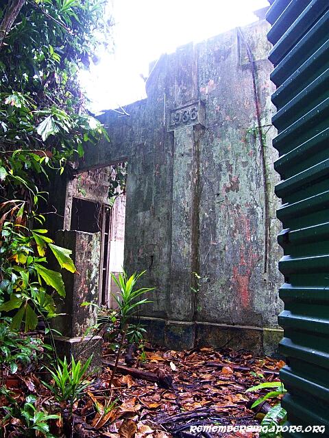
The weapons at the Blakang Mati fortifications were later upgraded through the arming of 10-inch guns, which had more firepower and longer range, and observation posts and battery plotting rooms were added in the 1930s to strengthen the forts’ defence capabilities. Some of the buildings on Mount Serapong today still bear the stone signage embossed with the year 1936.


The monster naval guns of the Blakang Mati forts and batteries, however, were never put to test against any attacks from the south. In early 1942, the Japanese invaded the northwestern side of Singapore from the Malay Peninsula. The guns had to be turned 180 degrees inland and, for three days, fired all their ammunition at the Jurong and Bukit Timah areas. But it was of little effect in stopping the advancing enemy forces.
With the impending fall of Singapore, the guns were then used to destroy the oil tanks at Pulau Sebarok and Pulau Bukom. After that, the guns and the batteries on Pulau Blakang Mati were also destroyed or broken up to prevent them from falling into the enemies’ hands. The island itself was then captured by the Japanese and Blakang Mati Artillery Barracks were used as a prisoner-of-war camp.

After the war, the Blakang Mati forts and batteries were handed over to a number of military forces, including the Royal Navy, Royal Artillery, Malay Coastal Battery and the Gurkha Contingent. Fort Serapong was still in use in the fifties – a 21-gun salute was fired by the Royal Artillery from Fort Serapong in August 1958 to mark the birthday of Queen Elizabeth the Queen Mother (1900-2002).
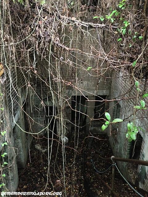
With the withdrawal of the British forces starting in 1967, the fortifications came under the command of the Singapore Armed Forces. The buildings were used as storage for several years before the government decided in 1972 to redevelop the island into a tourist destination. During the redevelopment, Fort Siloso was restored and converted into a military museum to display its past and antique coastal guns that were moved from the island’s other forts and batteries. Fort Connaught, on the other hand, was demolished to make way for the Tanjong Golf Course. As for Fort Serapong, it remains in ruins and abandoned state till this day.


Today, the long upsloping Serapong Hill Road that leads to the ruins of Fort Serapong is also the road to the Sentosa Service Reservoir, a small protected water catchment area managed by the Public Utilities Board (PUB). At the top of the hill, one can have a splendid panoramic view of the city.

A Summary of the British’s Coastal Fortifications and Batteries in Singapore:
Fort Fullerton (1830-1873)
Fort Palmer (1855-1905)
Fort Canning (1861-1907)
Fort Faber (1859-1862)
Fort Teregah (1861-1942)
Fort Tanjong Katong (1879-1901)
Fort Connaught (1878-1942)
Fort Serapong (1885-1942)
Fort Siloso (1898-1942)
Fort Pasir Panjang (1898-1942)
Fort Silingsing (1901-1942)
Targem Fort (1939)
Beting Kusah Battery (1939)
Changi Battery (1939)
Johore Battery (1939)
Buona Vista Battery (1939)
Pasir Laba Battery (1939)
Labrador Battery (1939)


Published: 06 June 2016
Discover more from Remember Singapore
Subscribe to get the latest posts sent to your email.


Thank you for the great history lesson and the pictures, I appreciate you doing this for your readers.
Reblogged this on Truth Troubles: Why people hate the truths' of the real world and commented:
This is an excellent article I hope that many of you will also read it. This is a great history lesson that I personally knew nothing of.
interesting, maybe they can redevelop this fort serapong, then there will be one more attraction in sentosa.
Thanks for the valuable info and the pics on Pulau Blakang Mati. I went there as a young boy in the 60s when the 10th Gurkha Rifles were based on the island. Still remember the big guns pointing towards the South China Sea, supposedly to thwart an invasion by the Japanese from the sea. The Japanese Army, as you pointed out, preferred to enter Singapore from the north instead.
Hi, could you please tell me how to reach Fort Serapong? According to the 2012 Street Directory, Serapong Hill Road which leads to the ruins is located next to the satellites in the vicinity of Sentosa Cove. However, went I went there for myself, the road was claimed to be for “authorised vehicles only”.
Thank you very much.
Yes, the Woolwich Road and Serapong Hill Road are for “authorised vehicles only”, but you can access the roads by foot or bicycle.
Speaking of Sentosa, I remember visiting a Coralrium which was located on the east side of the island. I remember it distinctly since my mum too my sister and I to visit it when I was about 8 or 9 years old. However, I cannot find any reference to it other than a minor mention about it in a SGforum post about ghost stories. Do you recall any stories about that attraction?
Hi there, yes the Coralarium was one of the first attractions on Sentosa. It was opened in 1974. By the early eighties, the structure was falling apart, and coupled with the falling visitorship and the need to refresh the island’s attractions, the Coralarium was closed in 1983.
Answering to the last comment, I managed to find a shot of the Coralrium that you’ve visited.
http://www.singaporememory.sg/contents/SMB-47a4736f-c334-4680-899c-2232ddb12f81
Seems like there’re not much records of it being documented.
I explored the place in 1989/1990 (?) with my primary school buddies, there is another tunnel complex at the top of the hill. Even then the path was already concealed by overgrowth and not easily spotted unless you look carefully. Fast forward to almost thirty years now, i think it would be near impossible to spot it unless intend to do some serious bashing thru the vegetation. Once inside that tunnel complex on the 2nd sub-level there is a hatch opening which has a steel ladder about 7 to 8 storeys high leading down to a bunker/lookout post at the bottom of the hill, which is full of bats and the floor inches deep with guano. There is also an underground water reservoir tank facility near that bunker.
is is still here today? reslly hope for a reply, would love to explore this place, tbank you.
Yes, it is still there. There’re no demolition or redevelopment plans yet.
hi, really helpful information. just wanted to check is fort serapong still there? is it demolished? really hope for a reply as i want to explore the place, thank you.
Pingback: Hidden Singapore: The Deep, Dark and Dilapidated – The UrbanWire
Lived on Blakang Mat 1950 till 1953 as a 6 year old. Great days, local school from 8.30 till 12.30 then we had the run off the Island! Far end with mangroves we called crocodile-creek, great fishing & there was also a cemetery, could have been Budist? Often wondered what happened to the site. Our Amah lived in the local Kampong, & met her again where She still lived in the same Kampong, She was now married with her familly when this occurred in 1965. In 1919 I managed to locate her with the help of Yeo Tze Yang, a local artist! Fantastic! Managed to get up Woolwich Road to the top of Mt. Serapong, very humid that day. Looking to go back one more time after this virus ends, soon I hope!
Pingback: Hidden Singapore: The Deep, Dark and Dilapidated