
Located at the junction of Cambridge Road and Carlisle Road, this old one-metre flood gauge serves as a reminder of the frequent floods that occurred in this vicinity especially in the seventies. Such flood gauges were installed at many low-lying areas in Singapore in the past, as a means to record the depths of the waters and the severity of the floods. Not many are left standing today.
Another one can be found along Commonwealth Avenue, near the MRT station, but its wooden frame and markings are in relatively poor conditions as compared to the Cambridge Road one.

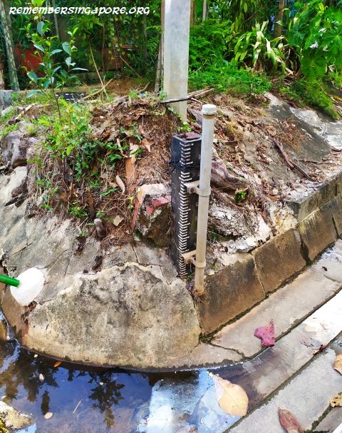
There is also an old flood gauge located along the canal at Kampong Lorong Buangkok.

In tropical Singapore, rainfall is plentiful and thunderstorms are common. On average, it rains 167 days a year (a rainy day is defined when the total daily rainfall reaches at least 0.2mm), with Novembers and Decembers receiving the largest amount of rainfall. According to the National Environment Agency (NEA), between 1981 and 2020, the annual rainfall in Singapore averaged 2166mm.
The wet climate means that Singapore has always been affected by floods. The particularly bad ones occurred, on records, in 1935, 1954, 1955, 1964, 1966, 1967, 1969, 1974, 1978, 1980, 1984, 1985, 1998, 2000, 2004, 2010, 2011 and 2013. The flooding often caused disruption of services, power failures, traffic congestions, damaged properties, and, in the worst scenarios, loss of lives.


For example, one of the worst floods in Singapore’s history occurred on 11 December 1969, a Hari Raya holiday. Incessant heavy rains led to many parts of Singapore to become severely flooded, with water depths almost at the waist’s level. Electricity and telephone lines were cut, whereas farms were drowned and poultry swept away. There were several deaths, caused by the landslides and fallen trees.
The government launched Operation Rehabilitation, made up of food distributions, rent subsidies and other aids to the affected residents and farmers to help them resume their lives and work back to normal. Major clean-ups were also carried out to remove piles of debris accumulated during the floods.

Another flood disaster happened on the early morning of 7 September 1974. Three hours of torrential rain led to a 38mm accumulation of rainfall, recorded by the Paya Lebar meteorological station.
The low-lying Jalan Besar and Rochor areas were hit badly – at one stage, the floods there were almost 2 feet (61cm) deep. Many houses at Cambridge Road, Geylang Serai and Bukit Timah were flooded, forcing their residents to move out temporarily. Hundreds of cars at the downtown and city areas were stranded, with huge traffic jams reported during the morning peak hours.

In December 1978, thunderstorms again caused disastrous flooding at the areas from Bishan to Potong Pasir. This time, the floods claimed seven lives, thousands of pigs and poultry and destroyed large areas of farms and crops.

Since the early seventies, almost $2 billion had been invested to improve Singapore’s drainage infrastructure. A drainage master plan was drawn in the mid-seventies by the Ministry of Environment. Major diversion canals were constructed. A large canal, for instance, was constructed at Ulu Pandan in 1970 as part of the anti-flood scheme. New towns and housing estates developed in the seventies were also designed with better drainage networks. By the late eighties, things had significantly improved.
Further enhancements were carried out after 2000. The Marina Barrage, opened in 2008, is equipped with pumps to flush out the water into the sea during thunderstorms. In many of newer buildings, detention tanks and retention ponds were also installed to slow down the flow of water, hence preventing the overloading of the drainage network within a short period of time.

The Public Utility Board (PUB) has also installed water level sensors and CCTVs at numerous canals and drains, providing the public with quick updates of possible flash floods. Today, flash floods still occur due to sudden surge of rainfalls, but the waters tend to subside quickly. These new advanced devices are a stark contrast as compared to the old flood gauges that were once found in the different parts of Singapore.
Published: 28 March 2021
Updated: 8 March 2022
Discover more from Remember Singapore
Subscribe to get the latest posts sent to your email.


About 20 years ago, I took some photos around Geylang area and they included 2 such markers. I can share the photos if they are useful to complete the study.
Well do I remember the floods, It brought back many memoreis, especially at the Orchard Road area, I lived in Scotts Road in the 1960s.
During One such flood, my wife had left her hair salon in preparation for a smart New Years Dinner, commenced to cross Orchard Road and plunged head first into a monsoon drain (before they were covered). She did not attend the dinner!
Captain Peter Tame, ex S.I.A.
I like to think that I’m pretty observant but I walk past Cambridge/Carlisle Road junction at least once a week and never noticed the flood marker! I had to go there today to prove to myself it exists…
My Secondary School days at ACS Barker Road was a school boy play event when we had to wade through the Dunearn Road to Newton on our way home. There was once the flood in 1966 that we had to stay in school overnight and guess what, it was a treat for us as young students spending an overnight stay with all our classmates.
I chance upon this website and am impressed as I grew up in Serangoon Gardens in the 50-70s, and know the sights, sounds and enjoyed the good old days with all its changes and remarkable progress. Yes, the many swollen torrential drains and floods which are practically non-existent today. This website is a treasure-trove of days of yore and could open the eyes of the young generations. Well done.
Added another old flood gauge found at Kampong Lorong Buangkok…
There is another Flood gauge, located in a drain next to the former Beatty Primary School, now SINDA. It appears to be in very good condition.
Wettest February day recorded on Feb 28, surpassing previous high in 1995
1 March 2023
CNA
Singapore experienced its wettest February day on Tuesday (Feb 28), with the highest daily total rainfall of 225.5mm recorded at Kallang.
This exceeds the previous high of 159.3mm on Feb 4, 1995, the Meteorological Service Singapore said on Wednesday.
The record rainfall was due to a monsoon surge – a strengthening of winds over the South China Sea, causing extensive rainclouds to form over the surrounding region.
It brought about continuous rain over Singapore, with all weather stations recording more than 100mm of rainfall, said the Met Service. The rain was heaviest over the eastern and southern parts of Singapore.
https://www.channelnewsasia.com/singapore/wettest-february-day-singapore-rain-feb-28-met-service-weather-march-3315141
From my travels, I can confirm a Flood Gauge stands at Former Beatty Primary School, in a drain near the junction of Beatty Rd and Sturdee Rd. It is behind the classroom block with the emergency fire escape staircase. It can be seen on Google Street View.
Another Flood gauge stood at the junction of Dorset and Owen Rd, right next to a traffic light, coincidentally also next to a school, Owen Primary School. This gauge was destroyed before 2013, as it disappears from Google Street view. This is probably due to the widening of the pavement around that time.
The Commonwealth Station Flood Gauge has likewise been destroyed. I made my way down in April and May 2023. I failed to see the flood gauge. A check on Google street view shows a new pavement where the flood gauge once stood was built around 2022. Thus, this Flood gauge has finally been swept away by the flood of progress.
Lastly, the Kampong Lorong Buangkok Flood gauge and Cambridge Flood gauge are still around, as of May 2023.
Highest-ever January rainfall in Singapore recorded on Pulau Tekong
14 January 2025
The Straits Times
The recent downpours amid a monsoon surge in Singapore hit a new peak for rainfall, with the heaviest-ever showers to fall in January recorded on Pulau Tekong on Jan 10.
Rainfall on the offshore island was more than double the average amount of rain that fell on Jan 10 across Singapore’s 32 weather stations, since records began in 1980.
Pulau Tekong recorded 241.8mm of rain that day, surpassing the previous high of 238.2mm recorded on Jan 30, 2011, on Pulau Ubin, said the Meteorological Service Singapore (MSS) on Jan 14 in response to queries from The Straits Times.
The highest rainfalls are usually recorded over the northern and eastern parts of Singapore, it added.
Prolonged rain dumped on Singapore between Jan 10 and 13 was the result of a recent monsoon surge, which is a seasonal weather phenomenon that brings about increased showers in the tropics.
During this period, islandwide average daily total rainfall ranged from 44.4mm to 120.2mm, said the MSS, which is part of the National Environment Agency (NEA).
These surges are typical for the wet phase of the north-east monsoon that tends to last from December to January.
Highest-ever January rainfall in Singapore recorded on Pulau Tekong | The Straits Times