

The National Library’s “Selling Dreams: Early Advertising in Singapore” exhibition features many advertising materials from the 1830s to 1960s, with snippets of information about the advertisers and their publications, their dreams and aspirations, as well as the way the changes in the society, over the years, affected their designs, which in turn influenced the society.
Modern advertising agencies started appearing in Singapore in the 1920s. Vibrant and competitive, the early ad industry was dominated by Western expatriates – either based here or had regional firms with headquarters at Hong Kong or Shanghai – who actively advertised their services in publications for the business community.
One of the early modern advertising agencies was the Advertising and Publicity Bureau (APB), established in Hong Kong in 1922 by Beatrice Thompson. In 1931, it became the first regional agency in Singapore when it opened one of its branches here. Advertising for many household brands and prominent firms, APB claimed, in the 1930s, to be the largest advertising agency in the Far East.

For Chinese adverts, picture calendars were common advertising tools used by businesses as gifts to their clients. Featuring Chinese women dressed in the latest fashions, they originated from Shanghai and were extremely popular between the 1920s and 1940s. Many local publication firms were engaged in the design and printing of such picture calendars, often in full colours.

During the Japanese Occupation, most of the advertising agencies were forced to cease their operations. They resumed their businesses after the end of the war, and were joined by many newcomers in the ad industry. The fifties and sixties saw more British, American and Australian advertising firms entering the Asian market, some of which later became leading international firms.
Two prominent post-war advertising agencies were Cathay Advertising and C.F. Young Publicity. The former was founded in Hong Kong by Elma Kelly, an Australian businesswoman, and had its Singapore office opened in 1946. By the sixties, it became one of Singapore’s largest advertising agencies. Cathay Advertising later merged with Australian firm George Patterson and was subsequently acquired by New York advertising giant Ted Bates & Co in the late sixties.

C.F. Young Publicity, on the other hand, was established in 1946 by C.F. Young, who was originally a manager from APB. Also a leading advertising agency, it was later renamed Young Advertising and Marketing, before being acquired by British advertising agency London Press Exchange in 1966 and became LPE Singapore.
Food & Beverage
In the early 20th century, the global revolution in food consumption, aided by the new food-related technology such as aerated water, preservatives, refrigeration and tinned food, meant that there was an increase in locally and foreign manufactured food products, which in turn led to a rise in the demand of their advertising in books, magazines and newspapers.

The advertisements often portrayed imported food products, such as chocolates and biscuits (above), as some form of luxury products, which made their consumption associated with modern, affluent lifestyle. Hence, the adverts would usually be made up of illustrations of happy, well-off families with scrumptious meals.
After the Second World War, especially throughout the sixties, the influx of foods and seasonings from overseas largely altered the local taste and cuisines. Foods such as tomato sauce and margarine became common, and their advertising (below) were targeted mostly at women, who were traditionally in charge of home cooking. Some of the popular advertising platforms for the advertisements of these household staples were female magazines such as Her World.


Coffee and tea (above) were also highly sought-after imported food products. Other beverages such as flavoured drinks and aerated waters were also popular due to Singapore’s hot and humid weather. Many of those drinks were manufactured locally. One of the industry’s early brands was Framroz & Co, founded in 1904 by Parsi businessman P.M. Framroz. Its Orange Smash was so successful that the company was hailed as the “pioneer of fruit juice drinks” in Singapore.
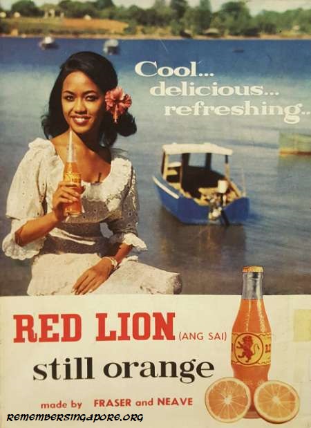 Another household name was Fraser and Neave (F&N). Although it started as a printing and publishing company in 1883, F&N later switched to beverage business by supplying aerated water, lemonade, tonic, ginger ale and beer to clubs, hotels and residences in Singapore.
To reach out to the masses, F&N advertised its products heavily, especially in one of its star products Red Lion (right) in the sixties. Its advertisements of female models sipping cold refreshing Red Lion orange drinks were so commonly seen that F&N earned the colloquial name of “ang sai” (red lion in Hokkien) among the locals.
Supermarkets
Food refrigeration had completely changed the way the food was consumed, both globally and in Singapore. Fresh meat, dairy, fruits and vegetables could be shipped and kept fresh for a significant period of time, allowing European residents in pre-war Singapore to maintain their Western lifestyles and diets.

This led to the rise of Cold Storage (established in Singapore in 1903), Fitzpatrick’s (established in 1958) and Fresh Food Refrigerating Company, which became well-known supermarkets with a wide range of fresh imported produce. Prolific and competitive, their advertisements (above) were eye-catching, and were designed with strong emphasis of their fresh supply, convenience and comfort shopping in their air-conditioned supermarkets.
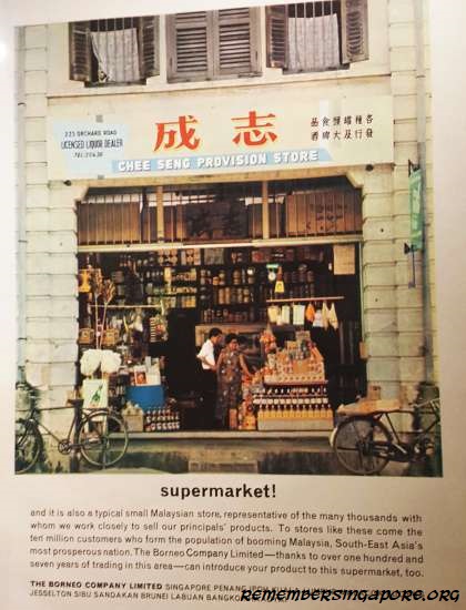 Local retailers were not to be left out. Local trading firm The Borneo Company, which had a long history and had many branches in different parts of Malaysia, Brunei and Thailand, found effectiveness in its active advertising of its trading and distribution services.
By comparing provision shops – it supplied to thousands of provision shops in Southeast Asia, such as Chee Seng Provision Store, the one featured in the full-coloured advert (left) – to the regional equivalent of a supermarket, The Borneo Company highlighted the convenience and the wide range of the products and services that the provision shops provided to its customers.
Supplements & Tonics
From the late 19th century to the early 1920s, the public in Singapore increasingly grew to become more conscious of the relationship between one’s health and his diet. Observed by many advertisers, they marketed their food products based on the people’s desire for a healthy and long life. In the advertisements, many food products were portrayed as tonic food with additional nutrients; others claimed to boost one’s health, strength and energy, or aid in slimming or dieting.

Due to the high infant and child mortality throughout the mid-20th century, mothers’ biggest concern was the health and well-being of their children. As such, advertising of supplements and ointments were common and frequent. Examples were the cod liver oils by Scott’s Emulsion and Seven Seas (below), both of which were heavily advertised for their benefits to pregnant mothers and their children.

However, the market was soon flooded with so many different types of health food products that the public was often confused by their factual information. In the sixties, the Medicines (Advertisement and Sale) Ordinance was introduced by the authority to put an end to the advertisements of those products without the backing of authoritative researches.
Alcohols
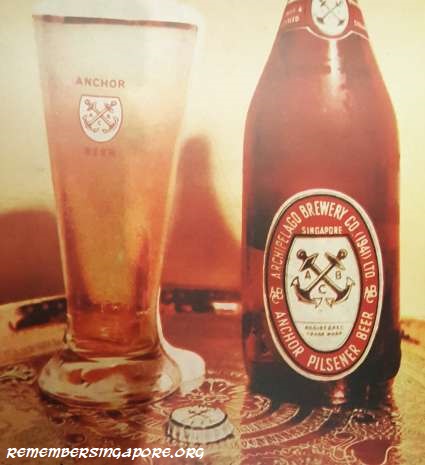
Alcoholic beverages in Singapore had a long history, ranging from imported beer, liquor, whiskey, gin, port and brandy. Overseas brands often tried to attract local drinkers by associating themselves with local cultures. For example, Carlsberg, with its signature green bottles, referred itself as “Carlsberg hijau” (green in Malay). Others advertised themselves as the alcohol used in famous local inventions such as the Singapore Sling and the “stengah” (a cocktail mixed of whiskey and soda). Local beers did not come into the picture until 1932, when the locally-brewed Tiger Beer was launched.
 Until the 1960s, it was common for beer adverts to feature vibrantly coloured images of beer served in cold, similar to those soft drinks adverts, giving the readers an impression of a perfect drink in Singapore’s tropical climate.
One of the popular alcoholic drinks was Anchor Beer (right), produced by the Archipelago Brewery Company, a German company that started brewing beer in 1933 at their Alexandra Road factory. The company was bought over, after the Second World War, by Malayan Breweries, the brewery that had produced Tiger Beer.
Electrical Appliances
When electricity became an integral part of the household, so were the consumer products in electrical appliances. In general, the ones heavily advertising the electrical appliances were the department stores, local dealers and major brands such as National (below), General Electric Company, Morphy-Richards and others.

At the start, electrical appliances were affordable only to the better-off families. For example, an electric iron in 1947 cost $11.50, equivalent to a factory worker’s two-month salary. However, by the fifties and sixties, the electrical appliances would become more affordable and accessible to the middle-class households. This led to their more extensive advertising, which tried to infuse the concept of a “modern home” equipped with the latest home gadgets and home entertainment.
 A significant number of women in Singapore had entered the workforce by the 1950s and 1960s. The advertising companies understood that the new-age females had the tedious task of juggling between their jobs and housework. Therefore, many of their advertisements, for household and domestic goods such as electric fans, fluorescent lighting, gas burners and sewing machines (right), highlighted the convenience that the products could bring for the working women.
Other electrical appliances included radios (below), televisions, record players and other home entertainment that were considered luxury items at first, but later become household staples enjoyed by the family members together. Radios and televisions, especially, grew to dominate the media and communication industry, and their channels became important platforms used extensively by the advertising agencies to reach out to a much larger audience.
Automobiles
After the Second World War, cars in Singapore became more of a norm due to improved roads and more affordable cars. The huge popularity of the Singapore Grand Prix held at Old Upper Thomson Road in the sixties and early seventies also helped to spur the public’s interest in cars.
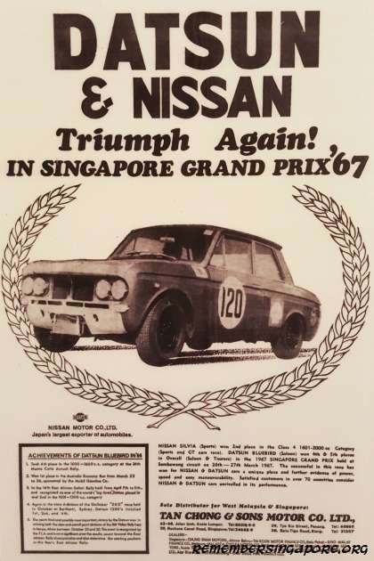 Many car manufacturers rode on to the competition’s popularity by sponsoring the drivers and advertising their brands, parading their car models in front of thousands of fans at the start of each race. For those car models or brands that won the races, it provided further advertising opportunities for the car companies to highlight their prized car’s speed, power, control and efficient fuel consumption.
For instance, the Datsun Bluebird of Nissan Motor was heavily advertised (right) in the late sixties, where its achievements (winner of Australian economy race, winner of Kenya’s Rift Valley Rally, 4th place in 36th Monte Carlo Rally, 4th & 5th place in 1967 Singapore Grand Prix) were proudly listed.
In Singapore, cars have always been used to symbolise wealth and prestige. Hence, even as cars became more affordable over the years, the car companies made it a marketing strategy by categorising their car models into “economy” and “luxury” cars, which catered to different groups of audiences.

For “economy”, or “family”, cars, their advertisements (above) often portrayed car ownership as part of a happy family. The car’s safety features, interior spaciousness, fuel efficiency and an affordable price tag gave an impression of a family’s perfect ride that clearly appealed to the masses.
Tourism
In 1872, Englishman Thomas Cook brought a group of tourists on a world tour, going to America, Middle East and Asia that included a two-day stay at Singapore, before returning to England. Since then, global tourism had become popular with more and more tourists making inter-continental travels.
For the travellers between Europe and Asia or Australia, Malaya usually became one of the stopover destinations. Hence, in the late 19th century and early 20th century, Malaya was often advertised as an exotic Orient – a land of tropical climate, magnificent scenery, multicultural society and rich in resources – with great potential business opportunities.

In 1901, the Federated Malay States Railway (FMSR) was established. Its Malay Peninsula’s west coast rail, made accessible by the 1910s, played an important role in promoting Malaya as a progressive place where the tourists could travel in style and comfort. FMSR was further connected to Siamese State Railway in 1918, making travel by rail between Singapore and Bangkok possible. This gave rise to the adverts (above) featuring the exotic images of both Malaya and Siam (Thailand).
The rapidly-growing tourism industry also boosted airlines and hotels. Malayan Airways made its maiden flight in 1947, and the airline soon carried tourists commuting between Singapore, Kuala Lumpur, Penang and Ipoh. Its flights later expanded regionally to include Thailand, Indonesia, Brunei, Sarawak and Hong Kong.
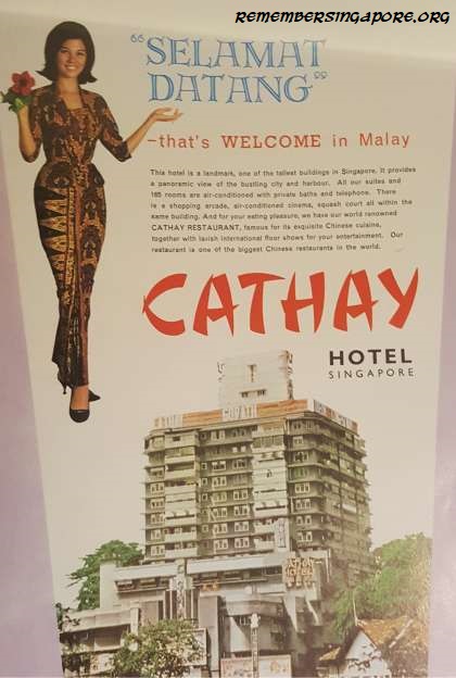 Cathay Hotel was one of the luxury hotels in Singapore that was heavily featured in the advertisements (right). The Cathay building, Singapore’s first skyscraper, was built in 1939, housing a cinema, restaurant and luxury apartments.
In the fifties, the Cathay Organisation, already a thriving entertainment business by then, moved to convert its luxury apartments into a hotel. The new Cathay Hotel was equipped with air-conditioning, telephones and private bathrooms. Within the building, there were also squash courts, cinema and shopping arcade.
Other hotels were determined not to be left behind in the booming tourism industry. Located at Eu Tong Sen Street, the six-storey Great Southern Hotel, also commonly known as Nam Tin Hotel, claimed in its advertisements that it was the most reputable hotels in Southeast Asia. Its Southern Restaurant and Southern Cabaret, located at the hotel’s top two floors, were its star attractions.
Another major attraction for tourists would be the local cuisines. Restaurants and eateries had their own advertising, usually on printed media such as posters, newspapers or magazines. Examples included the Jubilee Cafe & Restaurant that served Muslim food, curries and nasi biryani, Komala Vilas, one of Singapore’s oldest Indian vegetarian restaurants, and Cold Storage Creameries and their extremely popular Magnolia ice creams, also known as “milk bars” (below).

Shopping
The rapid development in trade and commerce in British Malaya in the mid- and late 19th century led to the rise of department stores. Singapore, being a major commercial hub and port of call, had the largest number of retail establishments.
One of Singapore’s most prominent department stores was Robinsons, established as a small retail outlet called Spicer & Robinson at the Commercial Square (present-day Raffles Place) in 1858. By the early 20th century, Robinsons had become one of the leading department stores here. It continued to flourish after the war, and was dubbed as the “handsomest shop in the Far East”, with regular promotion of its “Malaya’s Sale of the Year” – the equivalent of its successful Robinsons Sale in the later years.

John Little was founded even earlier, in 1845, as a retailer and auctioneer. In 1910, it opened its signature Raffles Place mall that was filled with wines, provisions, home furnishings, watches, books and men’s and ladies’ fashion. Rivaling Robinsons, John Little proudly declared, in many of its advertisements, that it was the “Finest Store East of Suez”. It, however, was acquired by Robinsons in 1955.

Another prominent department store was Whiteaway Laidlaw. Established in Calcutta, India in 1882, the British retail giant expanded its business throughout India, China and Southeast Asia. It opened its Singapore branch in 1900, and the department store was described as the “Whiteleys of the East”, referring to the famous London department store of the early 20th century. In Malaya, it was not until 1905 that the first non-European-owned department store – Chow Kit & Co – opened at Kuala Lumpur.
A photo gallery of the “Selling Dreams: Early Advertising in Singapore” exhibition and other featured advertisements:


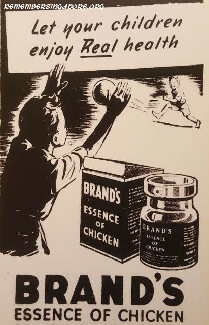
A simple black and white advertisement of Brand’s Essence of Chicken (above) in 1950
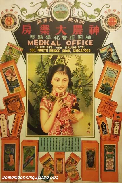
A full-coloured Medical Office poster (above) in the 1930s, designed in the popular Shanghai “picture calendar” style for a prominent local pharmacy at North Bridge Road

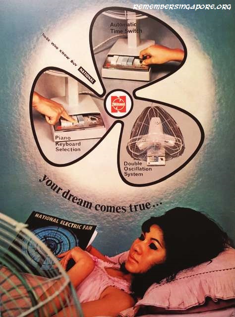
“Your dream comes true” – the motto for a 1964 National electric fan advert (above)
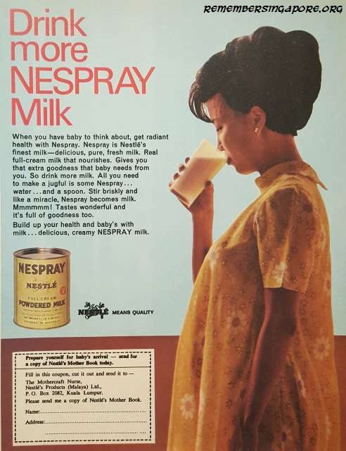
Advertisements promoting the health of pregnant mothers and their unborn children were common, as shown in this Nespray Milk ad (above) in Her World magazine in 1968

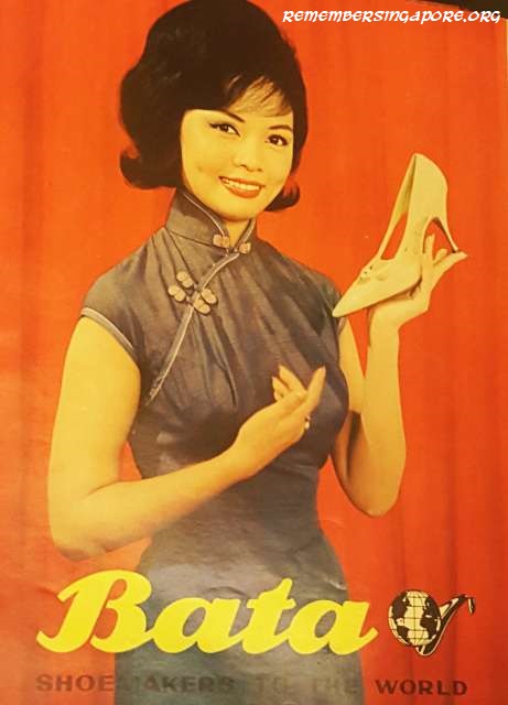
A Bata Shoe Company’s festival advertisement (above) for the Lunar New Year in 1951

Ocean liner adverts (above, left to right) in the 1930s – The Royal Dutch Mails, Danish East Asiatic Line, Peninsula & Oriental and British India Lines

(Editor’s Note: Most of the information in this article was referenced to the “Selling Dreams: Early Advertising in Singapore” exhibition at the National Library)
Also read Enter a World of Advertisement in Old Singapore (Part 1).
Published: 24 February 2019


 While most of Kampong Beting Kusa and Kampong Tanah Merah Besar villagers relocated their homes closer to the Changi coast, a number of affected kampong residents chose to move inland by resettling at Kampong Tengah and Kampong Darat.


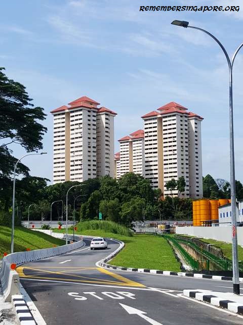


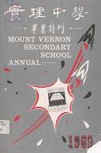 Maris Stella High’s neighbour was Mount Vernon Secondary School, established in 1968 and officially opened a year later by


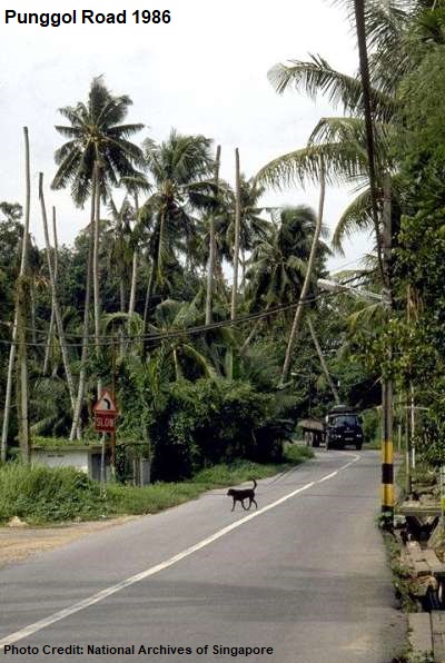
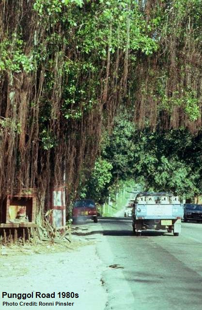 In the sixties, basic public amenities such as electricity supply, pipped water, street lights and metalled roads were introduced, through both government and gotong royong efforts, to the areas along Punggol Road.


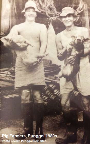 In 1975, the commercial pig farming at Punggol was started at Punggol Road 10


 On the other side of Punggol Road, one could reach the banks of Sungei Punggol via Track 13. In the seventies, the swampy area at the end of Track 13 was notoriously filled with stench as it was conveniently used as a dumping ground for dead diseased chicken and other garbage.


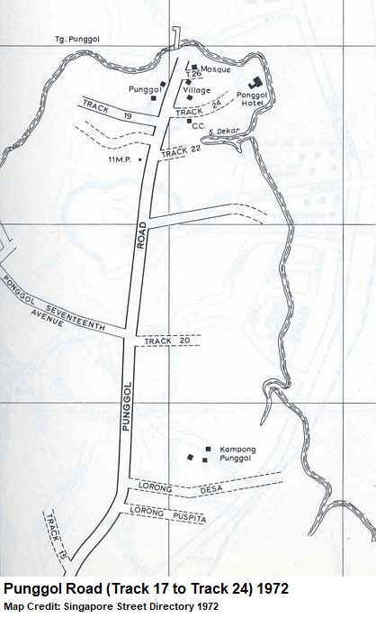 There were also several double-storey bungalows located at Punggol Road Track 24, owned by private owners who used them as seaside resorts during weekends.


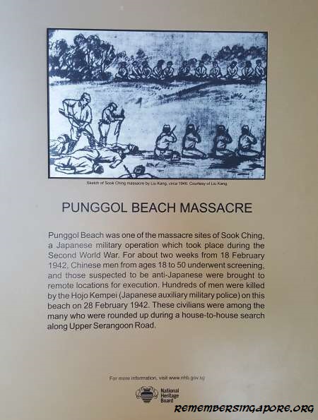 In February 1942, after invading and occupying Singapore, the Japanese carried out a series of Sook Ching (purging) operations. Hundreds of Chinese males living at Upper Serangoon Road were rounded up during a house-to-house search by the Hojo Kempei (Japanese auxiliary military police). Accused of anti-Japanese or triad members, the men were brought to the beach at Punggol before being gunned down.


")

")

