For over 150 years, the 3.2km-long Singapore River has played an important role in the economical growth of Singapore as a free port. Started from the mouth of the river, development gradually spread upstream. Population surged and trading activities flourished. By the early 20th century, the vicinities at Robertson Quay, Ho Puah Quah and Kim Seng were filled with ricemills, sawmills, boat yards, godowns and shophouses.
The increasing economic and social demands saw the need to link up the northern and southern sides of the river. Thus, bridges were built along the Singapore River to connect the north, where the government offices were located, and south banks, where cargo goods were unloaded from the boats.

Over the decades, the old bridges had been replaced by newer ones. Many had witnessed the transformation of the river and its surroundings in the past century. On 03 December 2009, five of the oldest bridges of the Singapore River were given the conservation status; they are the Anderson, Cavenagh, Elgin, Read and Ord Bridges, built between the mid-19th and early 20th century.
Singapore River’s Early Bridges
According to historical illustrations of old Singapore, the first bridge across the Singapore River was an unnamed wooden footbridge located near present-day Elgin Bridge. The bridge was built in 1819, the same year Sir Stamford Raffles founded Singapore.
Presentment Bridge
1822-1844
It was replaced three years later, by another wooden bridge named Presentment Bridge, also known as Jackson’s Bridge or Monkey Bridge. The Presentment Bridge later linked up North Bridge Road and South Bridge Road. The roads, named with reference to the bridge, were planned by George Drumgoole Coleman (1795-1844) and constructed in 1833 by his team of Indian convict labourers.

An Irish architect, George Coleman was the Superintendent of Public Works whose legacy included many roads, churches and buildings in Singapore of the early 19th century. The Coleman Bridge was named in honour of him, when it was completed in 1840 and became the Singapore River’s first ‘modern’ bridge made of bricks.
Thomson’s Bridge
1844-1862
Between 1827 and 1842, the Presentment Bridge was repaired many times. In 1844, the colonial government decided to demolish the bridge, and replace it with a new wooden footbridge. The new bridge was designed by John Turnbull Thomson (1821-1884), a British civil engineer and surveyor who designed and built many iconic structures and buildings such as the Dalhousie Obelisk, Horsburgh Lighthouse and Hajjah Fatimah Mosque.

Named Thomson’s Bridge, the footbridge was later widened to allow carriages to cross the river. In 1862, the bridge was replaced by an iron bridge imported from Calcutta, India (present-day Kolkata), and was renamed as Elgin Bridge.
ABC Bridge
undetermined-1884
ABC Bridge was a footbridge across the Singapore River where Clarke Quay is today. By the 1880s, the aging bridge was unable to cope with the growing demands between the northern and southern river banks, where godowns, wharfs and quay accommodations were rapidly increasing.
ABC Bridge was closed in 1884, and was replaced by the new Ord Bridge two years later.
Singapore River’s Heritage Bridges
Elgin Bridge
first 1862-1920s, second 1929-present
The first Elgin Bridge was built in 1862, when its iron-cast body was imported from Calcutta to replace the wooden Thomson’s Bridge. It was named after Lord James Bruce Elgin (1811-1863), the Governor-General of India from 1862 to 1863.
In the 1870s and 1880s, Elgin Bridge underwent widening and strengthening projects in order to meet the increasing demands and trading activities near the river, and also to allow the steamed tramways to cross the waterway. It was demolished on 24 December 1926 to pave way for the construction of a new Elgin Bridge.


The second Elgin Bridge was opened on 30 May 1929, after three years of construction by the Public Works Department. It was designed by local-based engineer T.C. Hood, who also designed the Crawford Bridge over present-day Rochor Canal. The bridge’s iron-cast lamp posts were designed by Cavalieri Rodolfo Nolli (1888-1963), the Italian sculptor and architect whose work included the reliefs for the Tanjong Pagar Railway Station, Old Supreme Court Building and College of Medicine Building.

The new Elgin Bridge was raised four feet higher than the previous one, so as to allow boats to pass under it during the high tides. It also had encased concrete around its steel structure, in order to prevent corrosion due to the fumes produced by the nearby factories and warehouses.
Fondly known as tee tiao kio (“iron suspension bridge”) by the local Chinese, Elgin Bridge was refurbished in 1989 and conserved in 2009.
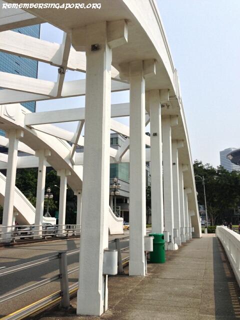
Cavenagh Bridge
1869-present
British engineer Rowland Mason Ordish (1824-1886) left his legacy with his unique “Ordish” cable-stayed bridge design with the Cavenagh Bridge at the mouth of the Singapore River and the Albert Bridge, built in 1873, at London.


Cavenagh Bridge had gone through extensive loading tests. At its factory at Glasgow, Scotland, its components were bolted together and tested using loads four times of the bridge’s weight. With the successful result, the components were packed and shipped to Singapore. After its assembly, it went through another live loading test; this time a company of 120 Sepoy soldiers were ordered to march over it.
Cavenagh Bridge was named after Sir William Orfeur Cavenagh (1820-1891), the last India-appointed Governor of the Straits Settlements between 1859 and 1867. The bridge itself was built to commemorate the 50th anniversary of the founding of Crown Colony of the Straits Settlements.


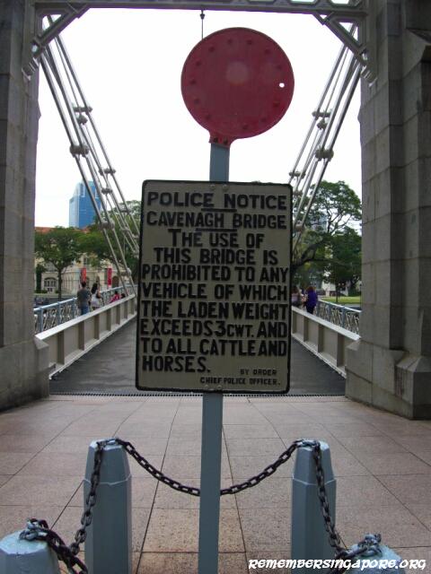
Trams used to run on the Cavenagh Bridge. However, in the early 20th century, the heavy traffic was diverted to the newly-built Anderson Bridge. A sign was put up at the entrance of the Cavenagh Bridge, declaring off-limits to “vehicles exceeding 3 cwts (hundredweight, equivalent to 50.8kg), cattle and horses”. Since then, it has been used as a pedestrian bridge.
Cavenagh Bridge was used to be known by the local Chinese as hai kee tee tiao kio, which means “iron suspension bridge by the sea”. During the high tides, cargo-carrying bumboats could not pass under it and had to wait for the low tides. Due to this flaw, the later Elgin Bridge was designed to be four feet higher than its previous version. In 1987, the bridge underwent a $1.5-million restoration. Today, it is the oldest bridge across the Singapore River.
Ord Bridge
1886-present
Ordnance Bridge, Toddy Bridge, “Bridge of Three Letters” or the new ABC Bridge, Ord Bridge is a bridge of many names. Designed in simple form with symmetrical balustrades and girders, it was meant to replace the old ABC Bridge which spanned across the Singapore River at present-day Clarke Quay area.

A few weeks after its completion in July 1886, the Public Works Department suffered a public backlash due to a “misalignment” in the bridge’s northern abutment, causing the bridge to be unstable. Ord Bridge was named after Sir Harry St. George Ord (1819-1885), the first governor (1867-1873) directly appointed by Britain after the Straits Settlements was given the Crown Colony status. It was officially opened in 1886 by another Straits Settlements’ governor Sir Frederick Weld (1823-1891).

Many toddy and liquor shops used to be found near the Ord Bridge, which gave rise to its other name of Toddy Bridge. It was also used to be linked to four roads; Magazine Road and Hong Lim Quay (defunct today) on its southern end, and ABC Road (later renamed as Ord Road, defunct today) and River Valley Road on its northern side. There was also a large iron foundry near the bridge in the late 19th century.


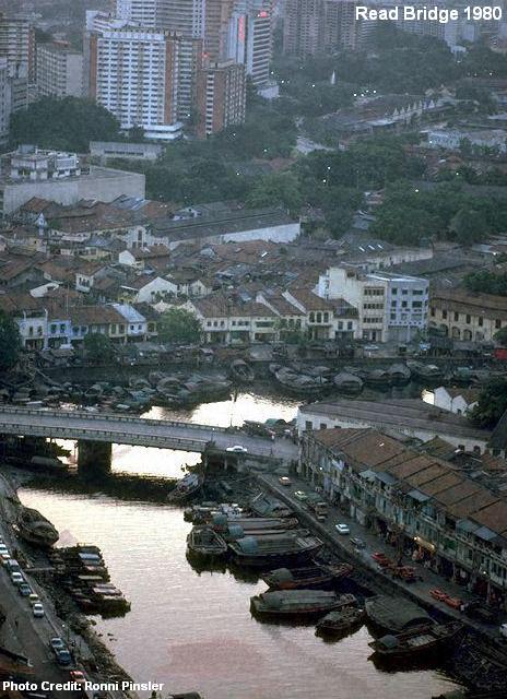
Read Bridge
1889-present
Originally known as the Merchant Bridge (or Merchants’ Bridge), Read Bridge was named after William Henry Macleod Read (1819-1909), a prominent businessman, the President of the Municipality and Honorary Police Magistrate who lived in Singapore for 46 years.
In early 1887, after laying the first cylinder for the bridge, a 69-year-old William Read returned to London for his retirement. Two years later, the Read Bridge was officially opened by the newly-appointed Governor of the Straits Settlements Cecil Clementi Smith (1840-1916).
Read Bridge links the uppermost limit of Boat Quay, which had a sizable Teochew community in the old days. The labourers and rowers from the twakows and tongkangs would often gathered near the bridge to listen to the Teochew storytellers; the location would become well-known as a story-telling centre.

The vicinity was also fondly known as cha choon tau (literally means “firewood boat head” in Teochew) due to the jetties built for the firewood-carrying tongkangs from Indonesia. The local Malays and Hokkiens referred Read Bridge as jembatan kampong melaka and kam gong ma la kat kio (both means “Kampong Melaka bridge”) respectively. Kampong Melaka was a Malay village that used to exist near South Boat Quay. Its mosque Masjid Omar Kampong Melaka, built in 1820, continues to flourish and is Singapore’s first and oldest mosque today.


In the early nineties, Read Bridge was restored in a $8.4-million project.
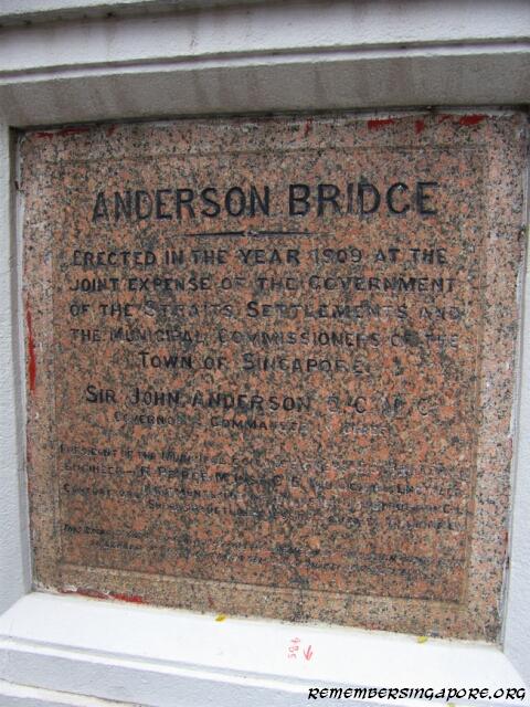
Anderson Bridge
1910-present
After three years of construction, the Anderson Bridge was opened on 12 March 1910 by Sir John Anderson (1858-1918), the Governor of the Straits Settlements between 1904 and 1911. It was designed by the Municipal Engineer Robert Peirce, who had Peirce Reservoir named after him, and was Singapore’s first steel bridge.

The 70m-long and 2.8m-wide bridge was constructed using 1,200 tonnes of steels imported from Britain; and its the non-structural parts such as the castings, railings and frames were fabricated by the Municipal workshops at River Valley Road. The bridge’s stone plaque was specially imported from Egypt, and high power gas lamps were used to lit up the bridge.


Upon its completion, the bridge’s total cost chalked up to £50,000, equivalent to $10 million Singapore dollars today. Due to the high cost, the bronze lions on each pedestal, originally designed by Peirce, were not added. The colonial government’s purpose in building a new bridge was to allow the heavier vehicles, horse and ox carts to cross the river, and also to relieve some of the overloading pressure faced by the nearby Cavenagh Bridge.

Anderson Bridge became a symbol of terror during the Japanese Occupation, when the Japanese would hang severed heads along the bridge to discourage the people from breaking the law. Its fortune changed after the Second World War; in the fifties, sixties and seventies, it became a favourite destination for lovers to take a stroll in the evening. Fondly known as Lovers’ Bridge, women would throw oranges into the river from the bridge during the last day of Chinese New Years, hoping to land a good husband.

Singapore’s Anderson Bridge has a twin in the Victoria Bridge at Brisbane, Australia. The latter, a fourth version, was designed by Australian Alfred Barton Brady. It was built in 1897 and replaced by a new Victoria Bridge in 1969.
Singapore River’s Other Old Bridges
Coleman Bridge
first 1840-1862, second 1865-1883, third 1886-1986, fourth 1990-present
In its 175-year history, there were four Coleman Bridges. The first was a brick bridge built in 1840. It was designed by and named after George Drumgoole Coleman, who was also Singapore’s first architect and the man behind the planning and construction of the North Bridge and South Bridge Roads.

As the second bridge built across the Singapore River after Presentment Bridge, the Coleman Bridge was also known as New Bridge. The road that was linked at its southern end became known as New Bridge Road. The bridge was 20 feet wide, and cost $8,700 in construction, a hefty amount during that time.
In 1862, due to the increasing traffic between the northern and southern sides of the Singapore River, the Municipal Commissioner proposed to replace the Coleman Bridge with a new one. Three years later, a new timber bridge was completed and was known as Canning Bridge, or the second Coleman Bridge.
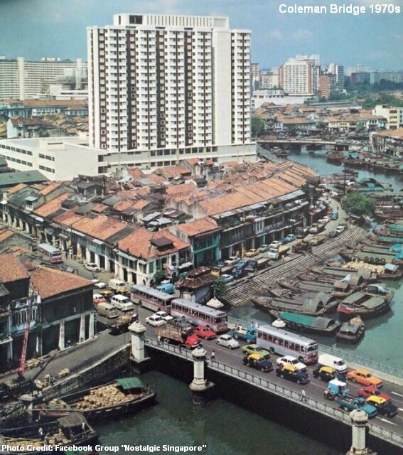

The second Coleman Bridge was, however, structurally unsound. Thus a new iron bridge was proposed to replace the old and shaky timber bridge, which was demolished in 1883. In July 1886, the third Coleman Bridge was built. Lasting a century, the third Coleman Bridge was considered the most aesthetically attractive bridge across the Singapore River. It was designed with many arches and columns and had ornamental gas lamp posts by its flanks.


Before 1986, New Bridge Road, an one-way road then, was the only access across Coleman Bridge, linking to Hill Street. Eu Tong Sen Street previously ended at its intersection with Havelock Road. The widening of Coleman Bridge allowed it to become a two-way traffic scheme with Eu Tong Sen Street and New Bridge Road in opposite directions. The widening project, which took four years and was completed in 1990, retained much of the decorative features of its predecessor.
Clemenceau Bridge
first 1920s-1938, second 1940-1989, third 1991-present
Clemenceau Avenue (formerly Tank Road) and Clemenceau Bridge were named after Georges Benjamin Clemenceau (1841-1929), the French Prime Minister (1906-1909, 1917-1920) who led his nation against Germany in the First World War. Georges Clemenceau had visited Malaya and Singapore on an eastern tour in the 1920s.
In 1938, a new bridge was built to replace the old corroding Clemenceau Bridge. Supervised by G.M. Wheat, the project, costing $250,000, was Singapore’s first bridge built with web girders. Measuring more than 100 yards long and 60 feet wide, the reinforced-concrete bridge was known as the new Pulau Saigon Bridge before it was renamed as Clemenceau Bridge in 1940.

Until the early seventies, Clemenceau Bridge was linked between the northern bank of the Singapore River and Pulau Saigon. On the tiny island, it merged with Pulau Saigon Road (now expunged) and was led southwards to Pulau Saigon Circus, which provided accesses to Havelock Road, Magazine Road and Chin Swee Road.
The vehicular bridges in which Pulau Saigon Road spanned over the river were simply known as Bridge No. 1 and Bridge No. 2. After Pulau Saigon was reclaimed and merged with the southern side of the Singapore River in the early seventies, Bridge No. 1 was relegated as a footbridge, whereas Bridge No. 2 was demolished.


This footbridge was demolished in the late eighties, together with the expunging of Pulau Saigon Road, during the second phase of the Central Expressway (CTE) project. In 1989, the CTE was extended to cut through the city between Bukit Timah and Chin Swee Roads. The old four-lane Clemenceau Bridge was also demolished and replaced by a new eight-lane one.
Pulau Saigon Bridge
first 1891-1986, second 1997-present
There were two Pulau Saigon Bridges in history, spanning across the Singapore River but located at different locations.
The original Pulau Saigon Bridge, previously located beside present-day Clemenceau Bridge, was built in 1891 and cost $71,000 of Municipal money. It linked up Pulau Saigon and the northern side of the river and was known as Pulau Saigon Bridge No. 1. Bridge No. 2, completed a year later, connected the island with the river’s southern bank.

The Pulau Saigon Bridge was raised in the early 1930s so as to allow bumboats to pass under it during the high tides. It was due to be demolished after the new Clemenceau Bridge was completed in 1940, but the demolition plans were shelved.
When Pulau Saigon was reclaimed in the seventies, the bridge was converted into a footbridge; its access to Merbau Road was cut off. The vehicular traffic was diverted to Clemenceau Bridge. It was not until September 1986, when the extensively rusted bridge was taken down to make way for the development of the CTE. In an 2-hour operation, the bridge’s joints on both ends were cut and the body lowered onto a barge. The dismantled steel pieces were then shipped to a Jurong scrapyard and sold for $22,000.


In 1997, a new 43m-long bridge was constructed 400m away from the original Pulau Saigon Bridge. The new Pulau Saigon Bridge links Saiboo Street to Havelock Road, cutting the travelling time between Orchard and Havelock Roads. The five-lane bridge is designed with granite pedestrian walkways and a 60m-long pedestrian underpass.
Kim Seng Bridge
first 1885-1950s, second 1954-present
The first Kim Seng Bridge, named after prominent Peranakan merchant and philanthropist Tan Kim Seng (1805-1864), was built in 1890. Spanning over the river near the Great World, its location was said to be the source of the Singapore River.
In the early 1950s, the increasingly heavy traffic and bottleneck at Kim Seng Road led to the planning of a new Kim Seng Bridge proposed by the City Council. In 1954, using pre-stressed concrete and high tensile steel, the new bridge was built at a cost of $370,000. Twice the size of its predecessor, the 26m-long and 20m-wide bridge was designed to meet heavy traffic conditions with its ability to hold a load of 13 tons per square metre.
Singapore River’s Other Bridges
The other bridges of the Singapore River are the Esplanade Bridge (opened in 1997), Robertson Bridge (1998), Alkaff Bridge (1999) and Jiak Kim Bridge (1999).

The latest is the $19.7-million Jubilee Bridge, opened to public in March 2015.
Published: 25 October 2015
Discover more from Remember Singapore
Subscribe to get the latest posts sent to your email.


Very informative, presented in simple and engaging manner.. Thanks! Always enjoy your posts!
Great post as usual… bite size informations.. Thank you.
Hi sir, may I know if you have the original pictures (without embossed credits) to Anderson Bridge 1980s, Cavenagh Bridge 1960s, Coleman Bridge 1970s, and Elgin Bridge 1980s?
pulau saigon bridge , I called black bridge is opposition river vaalley bridge was removed 1986, it waste for singaporean, there is few warehouse for storage rice, etc;
5 Things to Know about the Newly Gazetted Singapore River Bridges
15 October 2019
CNA
The Cavenagh, Anderson and Elgin Bridges have stood at the Singapore River’s historic mouth for decades, facilitating easy access between the waterway’s north and south banks.
On Tuesday (Oct 15), they were collectively gazetted as Singapore’s 73rd national monument, giving them the same status as other landmarks such as the Istana and Raffles Hotel.
More than just an easy way to get to Boat Quay or an aesthetically pleasing cameo in the Singapore Grand Prix, the bridges also illustrate Singapore’s growth as a trading port and flourishing city.
Here are some facts about Singapore’s newest official national monuments:
THEY’RE PRETTY OLD
Opened in 1869, 1910 and 1929, respectively, the Cavenagh, Anderson and Elgin Bridges date back to Singapore’s colonisation by the British.
Of the three, Cavenagh Bridge stands out as it is the oldest surviving bridge across the Singapore River. It is also one of only two remaining bridges in the world built with the “Ordish-Lefeuvre system”, a type of modified cable-stayed bridge design (the other is the Albert Bridge in London).
However, the present Elgin Bridge has an equivalent claim to fame – it stands at the site of the first footbridge to be built in Singapore (around the 1820s, and so earlier than the Cavenagh Bridge). It is the fifth bridge and second “Elgin Bridge” to be built on the site.
MADE IN BRITAIN
The structural components of the three bridges were manufactured in Britain and then shipped to Singapore. The engineers involved were also British, as were the bridges’ namesakes.
Cavenagh Bridge was named after Sir William Orfeur Cavenagh, the governor of the Straits Settlements at the time.
Anderson Bridge was named after Sir John Anderson, Governor of the Straits Settlements and High Commissioner of the Federated Malay States, while Elgin Bridge was named after Lord James Bruce Elgin, Governor General of India from 1862 to 1863.
NO CATTLE AND HORSES, PLEASE
Following the opening of Anderson Bridge, heavy traffic was diverted away from its older sibling, which was converted into a pedestrian-only bridge.
Keen-eyed members of the public crossing Cavenagh Bridge will be able to spot antique signs at the end of the bridge prohibiting “any vehicle of which the laden weight exceeds 3 cwt and to all cattle and horses”. Something to bear in mind next time you cross.
TRIBUTES TO ENGINEERS … AND LIONS
Apart from bans on cattle and horses, the bridges also feature tributes to their engineers. Cavenagh Bridge has steel plates emblazoned with its engineers’ names. Meanwhile, Elgin Bridge has bronze plaques engraved with lion symbols.
Lions didn’t quite make it for the Anderson Bridge – its original design featured a pair of bronze lions, but these were eventually left out for reason of economy, according to the National Library Board. However, the bridge does have a plaque made of red granite imported from Aswan, Egypt.
BUILT BY CONVICTS
Amid its status as the oldest bridge across the Singapore River, Cavenagh Bridge also has a more sombre past. It was built by convicts from India, with the NLB describing it as the “last major project undertaken by Indian convict labour”.
According to the board, Singapore began receiving Indian convicts from British India from 1825 to serve out their sentences, to assist with a labour shortage and development requirements.
Cavenagh Bridge was one of the monuments, bridges and other infrastructure built by convict labour in Singapore.
https://www.channelnewsasia.com/news/singapore/singapore-river-bridges-cavenagh-anderson-elgin-12002676
Connaught Drive and Anderson Bridge to be pedestrian-only from end-December
5 November 2021
Channel NewsAsia
Connaught Drive and Anderson Bridge will be fully pedestrianised as part of plans to further enhance the “walkability” of the Civic District, said authorities on Friday (Nov 5).
Visitors will be able to enjoy a “seamless walking experience” between Esplanade Park, Empress Place and the Padang once works are completed.
Members of the public will also be able to easily access the historical and arts offerings of the area on foot, said the Land Transport Authority (LTA), National Parks Board (NParks) and Urban Redevelopment Authority (URA) in a joint press release.
Connaught Drive will be fully closed to motorists as an extension of Esplanade Park and Anderson Bridge. Previously, Anderson Bridge only allowed pedestrians on one side.
Changes to traffic arrangements in the area will be implemented from end-December this year.
These plans were first announced at the Ministry of Transport’s Committee of Supply debate in March 2021.
The authorities said the start of works follow a series of engagements with various stakeholders over a four-month period since May this year, which yielded useful suggestions on ways to improve the pedestrians’ experience when they explore the Civic District.
“Agencies will continue to take into consideration stakeholders’ feedback in subsequent works to improve placemaking and wayfinding in the precinct,” they added.
Changes to traffic arrangements
– Connaught Drive, Anderson Bridge and Fullerton Road will be closed to all vehicular traffic. Only pedestrians will be allowed.
– The coach pick-up and drop points at Connaught Drive will be relocated to the nearby roundabout at Fullerton Road and Connaught Drive junction.
– Bus stop BS 02029 will be relocated to Esplanade Drive. Bus services 75, 100, 107, 130, 131 and 167 will be diverted to Esplanade Drive instead.
– Reconfiguration works at the junctions of Parliament Place and St Andrew’s Road, Fullerton Road and Connaught Drive, as well as Fullerton Road and Esplanade Drive.
– Once Anderson Bridge and Fullerton Road have been converted to allow only pedestrians, Parliament Place will reopen to all vehicles from end-December 2021.
Moving forward, the authorities said agencies will also work with stakeholders to plan open spaces to hold outdoor programmes for visitors, so as to bring “greater vibrancy” to the entire area.
The Civic District Alliance said that it was “happy to work with LTA to increase awareness and make the precinct more welcoming to the wider community”.
“These pedestrianisation plans are remarkable first steps to improve navigation and pedestrian connectivity not just within the area but beyond the Civic District in the future,” said the alliance.
NEW SIGNS AND POSTERS AT MRT STATIONS
New signs and information posters will also be rolled out at the City Hall and Raffles Place MRT stations from Friday, as part of improvements to placemaking and wayfinding in the area.
The signs and posters will be located prominently along walkways leading to the station exits and wall spaces above the ticketing machines near the faregates.
“With these posters, visitors will be able to easily obtain information on nearby iconic places of interest such as the National Gallery Singapore and The Arts House,” said the authorities.
LTA Chief Executive Ng Lang said: “The Civic District is home to some of our most significant historical monuments and cultural institutions, and the birthplace of modern Singapore.
“This is an effort by several agencies over several years to restore the beauty of the public spaces here.”
Mr Ng added that he hopes that visitors can walk “in leisure” to enjoy a glimpse of the past without having to compete with vehicular traffic.
LTA said it also intends to study public feedback and effectiveness of these placemaking and wayfinding initiatives, as well as work with stakeholders of other precincts of interest to bring their “distinct identities” into the MRT stations where possible.
https://www.channelnewsasia.com/singapore/connaught-drive-anderson-bridge-fullerton-road-pedestrians-only-civic-district-2293101
End of an era… Singapore River’s last two twakow, at Clarke Quay, will be removed due to their deteriorating conditions
新加坡河最后两艘大䑩船严重损坏难保存
Zaobao
27 June 2023
新加坡河的最后两艘大䑩船即将消失,人们在克拉码头再也见不到上世纪货运驳船的踪迹。
CQ @ Clarke Quay发言人说,他们与市区重建局、国家文物局、 公用事业局,以及旅游局等政府机构商讨保留位于克拉码头的两艘大䑩船的可行性。“经过全面的评估,这两艘大䑩船已经处于严重损坏的情况,如果保持目前的状态,很可能会对新加坡河造成环境风险。”
发言人指出,由于大䑩船年久失修,难以保存,当局并没有可以保留它们的方案。因此,CQ @ Clarke Quay正与有关当局合作,确保大䑩船能安全地从新加坡河移走,并把它们记录在档案中。
https://www.zaobao.com.sg/news/singapore/story20230627-1408493
Thanks for the Interesting history of singapore bridge. Chance upon your site while searching for singapore bridge history. I reference my ig post history source reference to your site. Do email me if you not comfortable of referencing your link in my Ig. Thanks